
The Fabric of Dreams
Upper Boston Post Road Entry #17 (UBPR #17)

“When I mention Worcester to people from New England, they often give a knowing nod or laugh — this unlovely, down-on-its-luck city of dead industry and collapsing buildings. But Worcester was an engine for betterment until the middle of the 20th century, a magical place that transformed lost and impoverished lives.”
Adam Davidson, What Happened to Worcester?
New York Times Magazine, April 27, 2016
“A dream is the fulfillment of a wish”
Sigmund Freud, The Interpretation of Dreams, 1899.
Introduction. Mile 48, continued.
The walks described in the previous two entries covered the short (0.8 miles) distance from the old Worcester County Courthouse in Lincoln Square through downtown Worcester to the United States Federal Courthouse at Main Street and Austin Street, an area rich in history, particularly history connected to the Upper Boston Post Road. Just south of the old Worcester County Courthouse likely would have been the original location of the milestone (now located in front of the Oaks at 140 Lincoln Street) indicating “47 miles from Boston.” Thus, the last two entries have been principally a description of a section of “mile 48” of my walk from the Old State House in Boston west to Springfield. The walk on the Upper Boston Post Road described in this entry, starting a few blocks southwest of City Hall, will continue along “mile 48” for a few more blocks. The walk will then continue along Main Street, the route of the Upper Boston Post Road, for another mile, taking in all of “mile 49” of the old road.
This area was a rural part of Worcester in the eighteenth century, with no landmarks shown on the 1795 map of the town and only a handful of buildings on Heman Stebbins map of Worcester produced in 1833. There is little evidence remaining from the eighteenth century along this section of road through a dense urban landscape, with the exception of a second milestone, the “48 Mile” stone, moved from its original location on South Main Street to a location on the other side of downtown. The absence of eighteenth-century artifacts and the presence of only a couple of buildings put up before the Civil War does not mean there is nothing to see or to write about on this walk. This section of the walk along the route of the Upper Boston Post Road affords me a rare luxury in that I have access to both detailed historic records for many of the buildings along the road in this area and to many detailed maps of the area spanning more than two-centuries, during which time Worcester grew from a town of 2,095 inhabitants to become the second-largest city in New England (with 206,518 residents in the 2020 United States Census). The relative paucity of older artifacts and concomitant stories about the eighteenth-century travels of people like John Adams or George Washington who might have described the area as they passed through, combined with the presence of so many interesting buildings from the last 150 years, presents an opportunity to use this entry to write a detailed analysis of the changes to the Post Road over the last two centuries along this section of the road. I apologize in advance for the extraordinary length of this essay and I admit that I probably went a little overboard, but I felt the need to take advantage of the abundance of historical research that has been done on the buildings in the area called Main South in order to produce a document describing the road as it is today and as it has changed over the years, as well as what it could have been.
One of my early formative intellectual experiences, as an undergraduate at Worcester Polytechnic Institute (WPI), was reading a book written by the cultural historian Carl Schorske entitled Fin-de-siècle Vienna: Politics and Culture. Described by its publisher as a “magnificent revelation of turn-of-the-century Vienna where out of a crisis of political and social disintegration so much of modern art and thought was born,” the book is structured into seven thematically interlocking chapters. Each chapter considers the interrelationships between key artists with the development of psychoanalysis and what was — at the time — viewed as an end of history. Using Vienna at the turn of the century as a backdrop, Schorske explained, in his introduction what a historian, unlike a specialist humanist (like an art critic, a philosopher, or a psychologist) should aim to accomplish when analyzing cultural artifacts:
The historian seeks rather to locate and interpret the artifact temporally in a field where two lines intersect. One line is vertical, or diachronic, by which he establishes the relation of a text or a system of thought to previous expressions in the same branch of cultural activity (painting, politics, etc.) The other is horizontal, or synchronic; by it he assesses the relation of the content of the intellectual object to what is appearing in other branches or aspects of a culture at the same time. The diachronic thread is the warp, the synchronic one is the woof in the fabric of cultural history. The historian is the weaver, but the quality of the cloth depends on the strength and color of the thread….he should spin the yarn serviceable enough for the kind of bold-patterned fabric he is called upon to produce.1Carl Schorske, Fin-de-siècle Vienna: Politics and Culture. New York: Vintage, 1981. p. xxii.
The genesis of this entire project is based principally on a variation of the idea suggested above. In this case the road along which I walk is the horizontal, or synchronic line, moving through space, while the buildings along the road, how they came to be, who lived in them, what happened in them (culture, politics, history, art), what was there before they were built, is the diachronic line, moving through time. The goal has always been to try to paint a picture of the road as it is now, what the road looks like, what it feels like, who lives there, what is similar and what changes as I move along, as well as to search for evidence explaining what the road might have looked like in the past, how the various parts of the road, the towns through which the road passes in this case, see themselves and connect with other towns along the road. It is not always a successful exercise, but it is always rewarding. My hope is, once again in the words of Schorske, “that, as in a song cycle, the central idea will act to establish a coherent field in which the several parts can cast their light upon each other to illuminate the larger whole.”2Schorske, p. xxviii. Walking the Post Road is that central idea.
The walk in this entry passes Clark University, where I was fortunate to be able to take a number of classes as a student in the Worcester Consortium of colleges, including the art history class where I first learned about the art and architecture along the Ringstraße in Vienna, about which Schorske devotes a significant portion of his book. Sigmund Freud, one of the principal subjects of Schorske’s book, gave a series of influential lectures at Clark University in 1909 (see photo above). In his book The Interpretation of Dreams, published in 1899, Freud postulates that “a dream is the fulfillment of a wish.”3See Schorske, pp. 181-182. This walk along Main Street in Worcester provides me with an opportunity to try to write the entry I have often dreamed of writing.
Chapter One: Expansion and Contraction

The sun beats down overhead on a hot July afternoon as I walk southwest along Main Street, the route of the Upper Boston Post Road in and out of Worcester. Also looming overhead on the west side of Main Street just south of Austin Street is the 6Hundred building, a 24-story apartment building that shares the title of tallest building in Worcester (along with the Glass Tower across from City Hall, a topic discussed in the last entry). The lack of trees in this built-up area of the city makes the sun seem even bigger and stronger than usual. As it happens, the sun is actually expanding, albeit at a pace so slow to humans, about 1% every 100 million years, that it is impossible to notice. Eventually (in about 5 billion years) the core of the sun will run out of hydrogen causing the sun to expand into a red giant that will consume the planets closest to it in the solar system, including Earth (which will have long run out of water and become uninhabitable), after which it will contract into a white dwarf, in which state it will remain for trillions of years before “before fading to a hypothetical super-dense black dwarf. As such, it would give off no more energy for an even longer time than it was a white dwarf.” It is probably the result of too much sun, but thinking about the life-cycle of the sun puts me in mind of the history of Worcester.
Cities also expand and contract, although the time frames are much shorter than those of stars. The formation and life-cycle of a city actually has quite a bit in common with the life-cycle of stars, and Worcester, the second-largest city in New England, is a classic example of the phenomenon of growth and decline that has characterized many of the American cities that expanded dramatically in the nineteenth century before beginning a marked contraction over the decades after the Second World War. It is on the periphery of downtown that the evidence of the expansion and contraction of cities like Worcester is most abundant. Among the many examples of expansion and contraction is the 6Hundred building itself, which was built as the “Sky Mark Tower” in 1990 and was the last of the high-rises to be built in a three-decade burst of activity from the late 1960s onward, a subject I discussed in the previous entry.
Before the high-rise building at 600 Main Street was put up on the edge of downtown during the last gasp of high-rise “fever” the neighborhood, comprised principally of elegant late-nineteenth- and early-twentieth-century mid-sized commercial buildings put up in a burst of expansion south and west from City Hall in the decades after the Civil War, had been in a period of rapid decline in the decades after the Second World War. The post-Civil War expansion encroached upon what had heretofore been primarily a residential district for more than a century. A detailed map of the city produced by Heman Stebbins in 1833 (see below) shows the town not much changed from the one described by Timothy Dwight a decade earlier: “The town is principally built on a single street, extending, from East to West, about a mile and a half on the road. It is situated in a valley and contains, as I judge, about one hundred and twenty houses generally well-built surrounded by neat fences, outhouses, and gardens frequently handsome and very rarely small, old, or unrepaired. Few towns in New-England exhibit so uniform an appearance of neatness, and taste or contain so great a proportion of good buildings, and so small a proportion of those which are indifferent, as Worcester.”4Timothy Dwight, Travels in New England and New York. New Haven, Timothy Dwight Publisher, 1821. Four volumes. p. 267.
On Stebbins’s map the houses are indeed clustered for a little more than a mile along the old road through the center of Worcester, beginning just north of Lincoln Square, a section of the road I covered in my first entry on the road through Worcester, then continuing south along Main Street (Dwight got his compass points mixed up) from the Courthouse in Lincoln Square to the Meetinghouse on the Common (covered in Worcester, Part Two), then continuing for another quarter-mile south of Town Hall (covered in Worcester, Part Three, the most recent entry). The last house south of Town Hall along the densely populated part of Main Street shown on the map is occupied by “A. Eaton,” before the road continues through much more open countryside lined with a few large estates of wealthy Worcester families. The “last” house, located at the southwest corner of Austin Street and Main Street, according to Caleb Wall in his Reminiscences of Worcester (published in 1877), was “the residence, three-quarters of a century ago, of Alpheus Eaton, the principal shoemaker of the period in this town. After his decease in 1832, the estate was purchased by William Stowell, who erected the present building upon its site, where he resided until his decease in 1853.”5Caleb A. Wall, Reminiscences of Worcester. Worcester: Tyler & Seagraves, 1877. p. 261.

*****
Thus the 6Hundred building sits on the site of the house of Alpheus Eaton, the house that marked the edge of the town of Worcester in 1833. However, even in 1833 signs of growth were apparent on Stebbins’s map; a little more than two miles along the Upper Boston Post Road leading south from Town Hall can be seen a new collection of buildings which sprang up along the brook over which the road crosses, a brook that merges with other brooks a little east of the road to form the Blackstone River. This area of nascent manufacturing was called “New Worcester” and is the area today known as Webster Square. Although the area along the road between the center of town and the newer manufacturing area remained a quiet residential enclave for a few more decades, the commercial and residential expansion of Worcester along Main Street south of the confines of Austin Street towards New Worcester continued relentlessly until well into the middle of the twentieth century. However, this expansion marked a brief high point in the growth of the city before the decline in manufacturing led to the economic contraction of the city, which in turn led to a demographic contraction as long-term residents emigrated to the suburbs or to the Sun Belt. The results of this contraction are visible all around me as I walk along Main Street through an area called “Main South” but so too are the signs of a new expansion. Worcester, a city built on immigration in the nineteenth century, principally from Europe, has in recent years experienced a surge in population as a result of immigration predominantly from the rest of the Americas, Africa, and Asia, a transformation that is particularly apparent along this section of my walk along the route of the Upper Boston Post Road through Worcester. The large Brazilian flag hanging out of the window of an apartment near the top of the 6Hundred building is only the first of many examples of today’s “New Worcester” as I follow the Post Road from downtown Worcester to an area once known as New Worcester.
*****
Chapter Two: What is, what was, and what could have been…

The 289-foot high apartment building at 600 Main Street is clearly visible from the steps of City Hall. It is only a few blocks down Main Street, which is also the route of the Upper Boston Post Road, the old road west out of Worcester in the colonial era. Affixed to a nearby plinth in front of City Hall is one of the markers I have encountered in every town on my walk along the old road from Boston to Worcester commemorating the route George Washington followed on his two trips to Boston (see photo). Washington first visited Worcester on July 1, 1775, on his way to take command of the Continental Army at Cambridge; Washington passed through Worcester a second time on October 23, 1789 during his visit to the “Eastern States” as President of the United States.6Strictly speaking, Washington visited only three New England, or “Eastern States,” Massachusetts, New Hampshire, and Connecticut. Vermont had yet to apply for statehood, Maine was still a part of Massachusetts and he did not go to what is today Maine, and Rhode Island had yet to ratify the Constitution and so Rhode Island was studiously avoided by Washington (he later made a separate trip back to Rhode Island, along Long Island and across to Newport by boat after they became an official State of the Union). Washington’s route through Worcester on both occasions took him along Main Street, the road in from the west and the road down which I travel on my way west through Worcester along the Upper Boston Post Road. The area around City Hall and the short distance from City Hall along Main Street, past Denholm’s, the Hanover Theater, St. Paul’s Cathedral, and the Federal Reserve Building in Franklin Square, to Austin Street and the apartment building at 600 Main Street was covered in the previous entry in this project.
This entry begins with the two-story building, also visible from City Hall, located across Main Street from the 6Hundred apartment building. Less than four hundred yards away from the steps of City Hall, at the northeast corner of Main Street and Madison Street, is the Worcester Market Building (see photo below. 1914; Massachusetts Cultural Resource Information System (MACRIS) reference number WOR.783),7Each building in the system has a unique identifier; the first three letters are a shorthand for the town or city in which the building is located (e.g. WOR is Worcester), while the three (sometimes four) digit number following the period is a unique number for the structure. Occasionally multiple buildings or even whole neighborhoods are listed under one identifier; these typically have letters after the period (e.g. WOR.F as we shall see further along the road, is the identifier for a set of two apartment building along Main Street built at the same time by the same architect). All of these can be found on the website of the Massachusetts Historical Commission. All further references in this article will put the MACRIS Report number in parentheses after the building, along with the date of construction. an astonishingly ornate building, with a terra cotta high relief of a steer prominently jutting from the center of an elaborate parapet above an ornate name plaque that extends across the entire half-block length of the building along Main Street, below which is a facade mostly comprised of windows framed by colorful green glass tiles. At the corners of the building are terra cotta medallions in which various animals such as pheasants and rams are displayed in relief; the decoration also continues for the entire half-block length of the building along the side facing Madison Street. It is a phenomenal building which, at the time of its opening in 1914, was “believed to be the largest grocery supply store in the United States” according to a report prepared by the Worcester Heritage Preservation Society in 1978 (the basis of the MACRIS Report, see footnote above).
This building typifies the expansion and contraction of the city of Worcester in the last two centuries. It comes as something of a shock to encounter this fantastic building only 200 yards south along Main Street past another astounding early-twentieth century building, the Hanover Theatre, about which I wrote in the previous entry on Worcester. The shock is not that there is yet another astonishing piece of architecture along the route of the Upper Boston Post Road in Worcester; the shock is at how rapidly the neighborhood declines just a block or so south of the newly vibrant Franklin Square, illustrating the challenge facing Worcester as it attempts to revitalize what had become, in the words of one long-time resident “a ghost town.” The redevelopment of the Hanover has been a success by all accounts, as has the success of the Canal District revitalization less than half a mile east of the Worcester Market Building, but huge swathes of Worcester, particularly the neighborhood called Main South, which runs south of downtown along Main Street as the name suggests, are a long way from their best days.
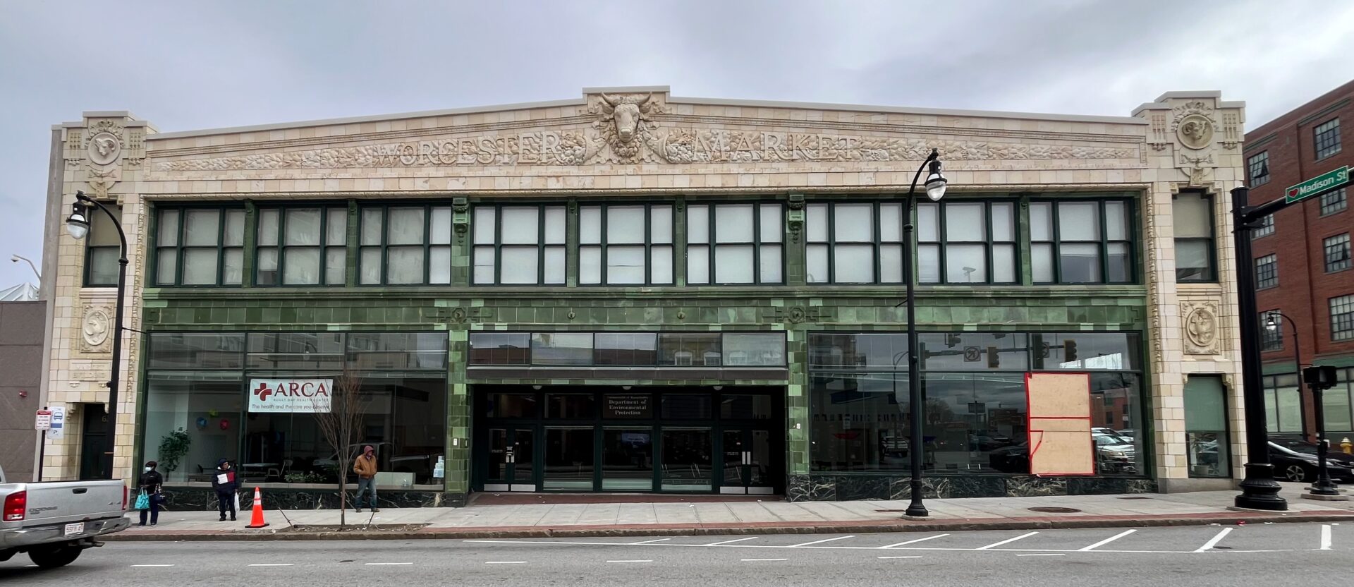
This lovely building, once a large and bustling market (according to Worcester historian Charles Nutt, writing in 1917, “in an ordinary Saturday’s trade, for instance, not less than 25,000 customers visited the store and at times during the day 3,000 were in the store at the same time),8Charles Nutt , The History Of Worcester And Its Peoples, 4 Volumes. New York: Lewis Historical Publishing Company, 1919. Vol. III, p. 887. was, by 1978, a Goodwill store, and later housed the offices of the Department of Environmental Protection; by 2014, it was vacant until it became the home of an adult day-care facility run by ARCA in 2018. On the days that I passed this building, the sidewalks on both sides of Main Street in front of the building were often crowded with people: some were clustered in small groups on the ground, and one or two were laying on the sidewalk, many of them unstable people, a few clearly suffering from the effects of some form of intoxicating substances. A Salvation Army building next door to the 6Hundred and across the street from the Worcester Market Building also attracted a crowd of people who waited outside for assistance (in what form I was unable to ascertain) reminding me of the infamous images of bread lines in the Depression. Despite the interesting architecture along this block, it is the single most depressing block I have encountered along the first 47-plus miles of the route of my walk along the Upper Boston Post Road. Unfortunately, several of the blocks ahead in the Main South neighborhood are as depressing as the one between Austin Street and Chandler Street.
It could have been different. An article from the Worcester Telegram & Gazette in 2019 about the “building the downtown redevelopment boom forgot” explained that “had an ambitious $6-million vision for the Worcester Market been realized, the building would have been restored as a bustling public market, less than a two-minute walk from the Hanover Theatre for the Performing Arts and an eight-minute walk down Madison Street from the planned new Polar Park….But the sale did not go through.” The creation of a Worcester Public Market did eventually occur, but in the Canal District, a nearby area that is rebounding after a long period of decline. Although Main South’s loss was the Canal District’s gain, it was doubly unfortunate that the Worcester Market Building was not utilized because the building was perfect for the planned project. As the Telegram article explains, “Deborah Packard, executive director of Preservation Worcester, laments the restoration of Worcester Market didn’t come to fruition. ‘It was unfortunate it fell through, because I think always the best use for a building is the original intended use.’ “

It is not the fault of the institutions located here that the neighborhood seems so dispiriting; rather, the fact that these establishments exist in buildings and in a neighborhood with potential to be much more vibrant and economically productive for the city is a sign that something is not working properly. The presence of a day-care facility (which would honestly be much more useful in a purpose-built facility located in a more densely populated neighborhood) in a building of such commercial potential, along with the presence of the Salvation Army building, numerous check-cashing establishments, various administrative offices of city and state government located in historic buildings that should be preserved or used for the purpose for which they were built, and the seemingly ubiquitous cannabis shops and liquor stores that litter long sections of Main Street are clear indicators that this is a “distressed neighborhood.” Someone walking through Main South does not need to study neighborhood poverty rates or per capita income statistics to figure out that this is a poor part of Worcester.
However, statistics show that this is indeed a poor neighborhood. The Household Median Income (HHMI) for Worcester, according to the United States Census Bureau (2018-2022 five-year estimate) is $63,011. The same number for all of Worcester County, of which the city of Worcester makes up 25% of the total population, is $88,524, while the number for the state of Massachusetts is $96,505. Shrewsbury, the previous town on the route of the Upper Boston Post Road, has an HHMI of $127,808, double that of Worcester. Considering that there are some very nice neighborhoods in Worcester, where people clearly have substantial incomes (the area around the American Antiquarian Society west of Worcester Polytechnic Institute is one example; Census Tract 7308.01 has a median HHMI of $155,000), there must be areas with a much lower HHMI than the already low number of Worcester as a whole. The area through which the Upper Boston Post Road passes southwest of City Hall is clearly one such area.9The Worcester Market Building and several more blocks southwest along Main Street are part of the Central Business District (Census Tract 7317), which includes a lot of new construction downtown as well as several revitalized buildings that have attracted a wealthier clientele. The HHMI for the area is slightly skewed as a result, but is still a relatively low $46,000. Neighborhoods further down the road will be discussed later in the entry.
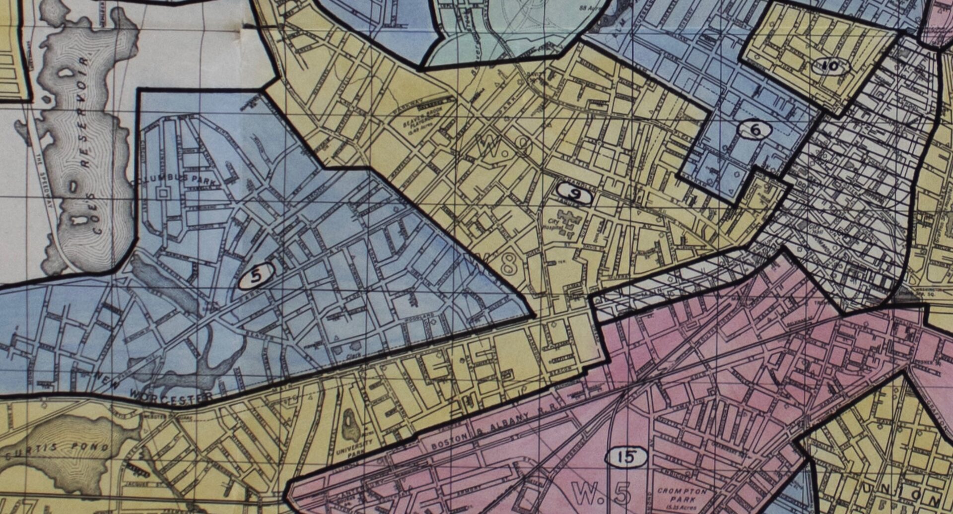
An article in the Worcester Business Journal (WBJ) entitled “Trapped: Worcester neighborhoods still suffer from the legacy of redlining” provides evidence that the area is still among the poorest in a city that is not particularly wealthy by Massachusetts standards. The article references a report from the Worcester Regional Research Bureau (WRRB) and uses maps provided by the Mapping Inequality Project showing areas that were “red-lined” beginning in the 1930s, essentially officially declaring the neighborhoods “hazardous” and consequently making it disproportionately difficult for residents in these neighborhoods to get mortgage support. According to the article, areas that were “red-lined” or “hazardous” in Worcester are still the poorest parts of the city. Although Main Street itself from City Hall to Castle Street was part of the “Business District” in the 1936 neighborhood maps, all of the area south of Main Street and most of the area north of Main Street (with the exception of the area around Clark University) were either “red-lined” (area 15 on the 1936 map, considered “hazardous”) or “yellow-lined” (area 9 on the 1936 map, considered “definitely declining”). Using census data for the tracts in the comparable neighborhoods today, the article concludes that area 15, with the highest “Non-white” population of any area, at 89.5% “non-white,” is the lowest ranked of the 15 zones on the 1936 map by “social vulnerability index score” (a “composite score from the CDC made from 16 data points indicative of levels of quality of human health”) and is 11th of 15 in “percentage of population below poverty level in 2020.” I have a few issues with the way some of the data is used and with a few of the conclusions in this article, but the data certainly support what is visible to the naked eye as I walk away from City Hall along Main Street: it is a “distressed” neighborhood.10One particular point I disagree with is the notion that the red-lined “area 15” is equivalent to Main South. First of all, No part of Main Street goes through area 15 on the 1936 map at all. Compare the map below with this official map of the Main South Neighborhood and it becomes obvious that only a very small portion of what is considered to be Main South today is a part of the red-lined area 15. Yet the article states explicitly that the “Main South area was considered the worst neighborhood in the city in 1936.” I would argue that the area considered the “worst neighborhood” in 1936 was the South Worcester area and the Canal District, which are both almost entirely in the red-lined area.
*****
It was not always like this; the road southwest from the center of Worcester once passed through a rural landscape dotted with a half-dozen large country retreats of wealthy Worcester citizens, principally members of the wealthy Chandler family. Later the area became a fashionable residential district filled with large Victorian houses, while later still large apartment buildings were built for middle class families. Slowly, commercial development spread along Main Street and apartment buildings transitioned to boarding houses. As factories closed and the economy of Worcester contracted, the commercial properties slowly closed or moved to the suburbs, and, by the 1960s, the neighborhood became “distressed” and many of the buildings along Main Street were empty or abandoned. Some of the questions that come to mind as I walk along Main Street to Webster Square and on to the neighboring town of Leicester include how the neighborhood got this way, what remains of the earlier version of Worcester shown on Stebbins 1833 map and later maps of the area, and what is happening to the neighborhood now to make it a better place to live, work, and visit?
The answer to the first question, in the immortal words of James Carville, is “the economy, stupid!” As manufacturing exploded in Worcester in the nineteenth century so too did the population, with people flocking to Worcester from the countryside and from abroad, principally from Europe, to work and to raise families, often starting new businesses which attracted more workers, in a virtuous cycle that continued for nearly a century. By 1900 the population of Worcester had exploded to 118,421 residents, from 17,049 residents at the Census of 1850 and 2,095 residents at the first Census in 1790. The city needed space to expand, space which was found on the roads passing through the fields and farms outside of the dense center of the city, especially along Main Street southwest of City Hall.
The first buildings to succumb to the wave of commercial expansion were the houses represented by the cluster of black squares on Stebbins’ map of 1833 (above) around Town Hall and the South Church, the grand old houses that once lined Main Street from City Hall to Austin Street, buildings like the eighteenth-century estate of Gardner Chandler (demolished in 1867), the neighboring house built by Benjamin Butman in 1828 (moved, in 1880, to a location just off Main Street at 14 Hammond Street about one mile south of its former site opposite Old South Church), the grand house built by Levi Dowley in 1842 opposite City Hall (moved to 700 Main Street in 1853, discussed later in the entry), and the property once owned by Alpheus Eaton, already discussed in this entry, at the corner of Main Street and Austin Street. These former residential areas became part of the downtown commercial district and the residential neighborhoods shifted further southwest along Main Street, a topic I discussed in more detail in the previous entry.
The Worcester Market Building was one of the last of these large commercial ventures to be built along Main Street southwest of City Hall. Illustrative of the changing nature of the city of Worcester, the architect of the building was one of the many thousands of immigrants who settled in Worcester. Oreste Ziroli arrived in America from Italy with his parents in 1890. The family settled in Fall River where Ziroli was raised and where he became an architect. Ziroli eventually settled in Worcester where, in addition to the elaborate Worcester Market Building, Ziroli also designed the building for the First Church of Christ Scientist at 880 Main Street, and likely designed the building at 751-755 Main Street for the F.S. Howard Motorcar Company, both discussed later in this entry. The buildings that sprang up along South Main Street after the Civil War were not only increasingly being built for new immigrants to Worcester; in most cases the buildings were also put up by immigrants to Worcester.
Many of the old commercial buildings along Main Street have long ago ceased to house the original industries or businesses for which they were built. Directly across Main Street from the Worcester Market Building, next door to the Salvation Army at 646 Main Street, is a building shown on Triscott’s map of 1878 as “Fallon’s Block Hotel” (1874; WOR.782), formerly a six-story hotel but currently a two-story building with a large garish sign for a liquor store on the ground floor obscuring the interesting architectural remnants of the once larger building. Sometime after 1878 the building was called the “Continental Hotel” which, according to the report on the MACRIS website “offered accommodations for ‘permanent and transient boarders’ at the rate of $2.00 per day, or $7-9 per week.” On Sanborn’s Insurance map of 1910 (Volume I, map 38) it is called the Hotel Stanwix. It is perhaps unsurprising that the transient nature of the neighbors and the increasing presence of large commercial structures prompted many of the the older families living in the area to sell up and move to greener pastures further down the road.

Across Madison Street from the Worcester Market Building is the impressive red brick Hadley Furniture Building (1924; WOR.2396) at 653-659 Main Street, topped by an engraved name panel across the facade above the fifth floor. At the time the MACRIS report was prepared by Preservation Worcester, in June 2000, the building was vacant, but it has since been renovated, with stores on the ground floor and apartments on the upper four floors. The report reiterates a theme I have been pursuing as I write about my walk along Main Street south of City Hall: “The Hadley Furniture & Carpet Company bought the old Leland house on the southeast corner of Main and Madison in 1924. They were participating in the recent trend of businesses moving out of the densely developed downtown to more spacious and economical real estate out on Main Street. The large, impressive homes that had characterized the boulevard were aging along with the families who valued them. Worcester’s rapidly growing middle- and working-class populations were also looking for improved housing around the fringes of the old nineteenth-century industrial city. South Main was an area in dramatic transition. With all the new housing being created, the furniture business must have been booming. The Hadley Furniture Company anticipated the need for more warehouse and store space to accommodate this demand, and their new location was ideally suited for easy accessibility. The house was nearly a century old at this point. Built by the Laphams, one of Worcester’s early manufacturing families, the house was bought by Frank A. Leland around 1900. Leland was proprietor of S.R. Leland & Son that had sold pianos, organs, band instruments and musical merchandise at 446 Main St. in the city since 1839. He transferred title to his daughter Hattie shortly before his death and her marriage to Daniel Kent; the Kents resided in the house until the Hadley Furniture & Carpet Co. moved on to the property in 1924.” The house can be seen on the corner of Madison and Main Streets on Triscott’s 1878 map of Worcester below, shown as the house of “M. Lapham.”
The elegant facade facing the Hadley building directly across the street at 660 Main Street is the former Hotel Aurora (1897; WOR.1059), claimed by Nutt, in his History of Worcester, to be “one of the best and most elegantly furnished hotels in the city, containing a hundred rooms.”12Nutt, Vol. III, p. 163. Today it too is an apartment building that is about to undergo a $10 million renovation of the 85 units of affordable housing. These are just two of many examples along the road of apartment buildings or commercial buildings once in varying states of disrepair or decay that have been renovated for mostly affordable housing. Despite the relative poverty of the typical resident of Worcester compared to neighboring towns and even to Boston, Worcester has a shortage of affordable housing and some of the highest rents in the state. In an ironic twist, the city of Worcester reached an all time population peak in the 2020 census (206,518 residents) and has a surfeit of what appear to be vacant buildings at a moment when the entire metropolitan Boston housing market has tightened to such an extent that Worcester has become a destination people are willing to choose despite the fairly long commute. However, many of the buildings are in need of renovation to make them inhabitable, hence the housing crisis, particularly at the bottom end of the market.
*****

*****
Chapter Three: The Lot of Main South

As I contemplate an easily overlooked empty lot just past the Hadley building, my walk is interrupted by a police action that takes place literally right next to me, as a Ford pickup truck is pulled over by a police car and, after some arguing and a quick identification scan, the driver is arrested and sits on the sidewalk continuing his dispute with what has become an audience of a half dozen police officers and a crowd of onlookers. Eventually the disputatious fellow is taken off in a wagon, and my schoolboy Spanish gleaned from overheard conversations that a brother-in-law of the person taken away in handcuffs was one of the onlookers, who summarized the situation by shaking his head and calling his now arrested relative “pendejo.“
The empty lot and the activity adjacent to it indicate that there is still a lot of work to do along Main South. However, a brief history of the lot and of the surrounding buildings is also a good illustration of the changing fortunes of the area over the last two centuries, the “lot” of Main South, if you will. A building stood on the site until 2009, when it was razed after failed attempts to redevelop what had been a warehouse for the Caravan Coffee Company, a longtime wholesaler in the city.13 this article, part of a series called Then & Now produced by Mike Elfland in the Worcester Telegram discusses the history of the Sears building Caravan took over the building in 1972, after the original tenant, Sears Roebuck & Co., had abandoned the building to become one of the anchor stores in the newly built Auburn Mall, five miles away near the junction of Interstate 90 and Interstate 290 in 1971, rejecting a putative move to the newly built Worcester Center on Worcester Common. The Sears store had earlier moved from 619 Main Street (next door to the Worcester Market building) to the larger new three-story brick commercial building with unusual Art Deco design characteristics (see photo) here at 661 Main Street with a grand opening on September 4, 1941. For three decades the building thrived at the southwestern edge of busy downtown Worcester, but moved along with many other businesses and people to the suburbs.

The Sears building replaced another building, the First Baptist Church, whose peripatetic congregation had moved on in the face of increasing commercial development and the increasing number of “boarding houses” along Main Street. The First Baptist Church, the “third organized body of worshipers in the town” had already followed its congregation once before, moving from its original location on Worcester Common to a new building erected in 1907 (see photo below) on the location of the currently empty lot on Main Street.14Charles Nutt , The History Of Worcester And Its Peoples, 4 Volumes. New York: Lewis Historical Publishing Company, 1919. Volume I, pp. 826-838 for the history of the Baptist Church in Worcester. The first converts in Worcester were baptized in 1812 and by 1813 the First Baptist Meeting House was dedicated in Salem Square, on the east side of the Common. As the congregation grew new branches were established, including the Third Baptist Church in 1855, a little further along Main Street from the empty lot once housing the First Baptist Church and the Sears building (discussed below). As downtown Worcester continued its transition from mixed residential and commercial buildings to predominantly commercial properties after the Civil War, many members of the congregation had moved into the burgeoning new neighborhood along South Main Street and so the First and Third Baptist Congregations merged (forming a congregation with 834 members) and moved into this new building, a building which burned in 1937 and the congregation, which had begun to find the “environment not comfortable” (according to the MACRIS report) relocated once again to its current location in the more tranquil (and wealthier) neighborhood at the corner of Salisbury Street and Park Street, near Worcester Polytechnic Institute.
The church replaced an even older building, a mansion occupied until the 1890s by the Mower family, one of Worcester’s oldest families. Major Ephraim Mower operated a tavern in the old John Chandler mansion across from Worcester Common, a subject I discussed in the previous entry. Major Mower’s sister Sally had married Charles Chandler, son of the wealthiest man in Worcester before the Revolution, John Chandler. John Chandler had abandoned Worcester in 1775 (and was subsequently exiled) owing to the unpopularity of his support of the Royal government. John Chandler’s wife Mary had remained in Worcester and managed to keep the property; upon her death in 1783, Charles and his family took over the mansion, but Charles died in 1798 and Sally died in 1801, leaving only their young daughter Sally (b. 1796) as heir to the estate. It is likely that Major Mower was the guardian of Sally Chandler, but he died, childless, in 1810, at the age of 62. His nephew, Captain Ephraim Mower took over operation of the tavern. Captain Ephraim eventually moved to a house in what was then the country, likely after selling the Mower Tavern in 1818 (the United States Hotel was built on the location of the original Chandler mansion/ Mower’s tavern, and was itself later replaced by the Clark Block [1854; WOR.766], which is still located at 401-409 Main Street in downtown Worcester). Stebbins shows the property of “E. Mower” as one of a half dozen buildings along the old road southwest out of town in his map of 1833. Captain Ephraim Mower (1778-1865) was twice married (to Nancy Lovell, d. 1822 and to Caroline Cutler, d. 1862) and had two children: Ephraim, who moved to New York in 1842 where he died, and Caroline Cutler Mower (1826-1897). Caroline Mower was unmarried, and she lived in the house until her death in 1897.15Photos of the house and a photograph of Caroline Mower can be seen on the digital photo archive of the Worcester Historical Museum.

Upon the death of Caroline Mower, according to the report on the property prepared by Preservation Worcester, the “heirs rented the place until they could subdivide the large property, which was over an acre of size in the midst of the city.” Looking at Triscott’s map from 1878 (see above) the large Mower estate stands out in the midst of many blocks along Main Street which have been subdivided and developed. The parcel was first divided in half with construction of Mower Avenue (now Ionic Avenue). The report also states that “the westerly side of the northerly half was sold (or given) to the First Baptist Church. The other side eventually became the home of the Worcester Boys Club. The part of the property south of Ionic Street was divided into seven lots facing Main, Ionic, and Beacon Streets. Harrison S. Prentice bought the two Main Street lots and built a large boarding house called the ‘Bellmar,’ which is still there. The remaining lots were deeded to the Worcester Masonic Charity and Educational Association, and the present Masonic Lodge was built there.”
The Worcester Boy’s Club building (1915; WOR.1197), the Masonic Temple (1914; WOR.1196), and the BelMar (1896; WOR.2398) are indeed all still extant, framing the empty lot that once was the center of the Mower Estate (see photo). The Masonic Temple is particularly majestic, with its imposing Ionic colonnade overlooking Main Street from its elevated site, hence the street name change from Mower Avenue to Ionic Avenue.16For a history of the Masons in Worcester, see Nutt, Vol. II, pp. 933-34. I have a long-standing obsession with Freemasonry which I will not share here in order to spare the reader (you are welcome). However, for some interesting history of Greek architecture and its meaning in freemasonry see this article. Other fraternal organizations also built headquarters nearby along Main Street in the same period, including the International Order of Odd Fellows (1906; 674 Main Street; MACRIS WOR.1193) and the Worcester Fraternal Order of the Eagles (1926; 695 Main Street; MACRIS WOR.2387). The BelMar is now called Maple Manor. According to the Preservation Worcester report “this section of Main Street is dense with large four- and five-story buildings. The Main Street streetscape is characterized by commercial uses at the street level and residential uses in the upper stories…the Bellmar is a distinctive example of a building planned as a boarding house and one of the options of progressive housing in turn-of-the-century Worcester.”

It is likely that the proliferation of buildings like the BelMar (the spelling on the 1910 Sanborn Insurance Map #231) and the nearby Sycamore Apartments (1926; WOR.2399; 685-689 Main Street), a building lined with storefronts on the first floor and small apartments, more affordable for working-class families, on the upper three floors, slowly contributed to the “uncomfortable environment” that lead to the eventual migration of the congregation of the First Baptist Church to more comfortable environs. The Sycamore replaced a house put up in an earlier wave of residential construction in the area that began in the 1840s. Sycamore Street (WOR.BY) was laid out in 1846, pushing the boundaries of the “outer edge of the built-up section of Worcester in the 1840s…encouraging the street’s gradual development with the homes of craftsmen and small businessmen.” The Greek Revival Style house, occupied by 1849 by the house painter, S.D. Newton at #8 Sycamore Street (1849; WOR.1162), just off of Main Street, is one of the city’s best preserved houses of this period and one of the oldest remaining buildings in the area. Another old house owned by Elizabeth Torrey as late as 1923 (and shown as owned by Robert Comstock in 1878 on Triscott’s map) was demolished to make way for the Sycamore apartment building.
Before the decline the neighborhood was expanding at a rapid clip, and an extensive apartment house district developed along this section of Main Street in the 1880s, with buildings like the Boynton (1887-88; WOR.F; 718 Main Street) and the Windsor (720 Main Street), designed to appeal to successful middle class tenants. However, changing demographics and the fluctuating economic fortunes of Worcester, particularly the effects of the Great Depression, changed the dynamic of the neighborhood and wealthier residents slowly moved to nicer neighborhoods further away from downtown, with the institutions they supported often following in their footsteps, or closing entirely. The International Order of Odd Fellows had over 3,015 members in 1917, by which time the organization had moved from Pearl Street downtown, to new headquarters “most conveniently located” according to Nutt, in the “opulent example of Beaux Arts Classicism” at 674 Main Street (1906; WOR.1193), now an apartment building.17Nutt, Vol II, pp. 937-939. Another organization, the Worcester Fraternal Order of the Eagles (1926; WOR.2387), opened their impressive meeting hall nearby in 1926, where the relief sculpture of an eagle still looks out over the street from the redbrick facade at 695 Main Street. The organization vacated the building by 1942 and, when the historic structure report was prepared by Preservation Worcester in June, 2000, the building was occupied by the Worcester Public Inebriate Program “indicating the low community status the building had reached.” Today the building serves as the meeting house for the Ebenezer church, an evangelical Hispanic congregation.
*****
Photo Gallery: Apartment Buildings along South Main Street in Worcester


The once predominantly rural retreats and farms along the old Upper Boston Post Road from City Hall southwest to the border with Leicester first began to be broken up into residential developments in the 1840s and 1850s, with new streets built leading away from Main Street and blocks divided into house lot; the pace of development increased rapidly after the Civil War. By the 1880s, population growth and expanding development from downtown led to a wave of construction of large apartment buildings designed for middle class families. Apartment buildings continued to be built through the 1920s, although less ambitious in scale and with smaller, more affordable units (like the Chavoor buildings) for the less wealthy clientele now moving into the area along Main Street south of City Hall. In recent years many older buildings along Main Street have been repurposed for residential living, like the Hadley Furniture building mentioned above, and the Hotel Aurora, shown in this gallery.
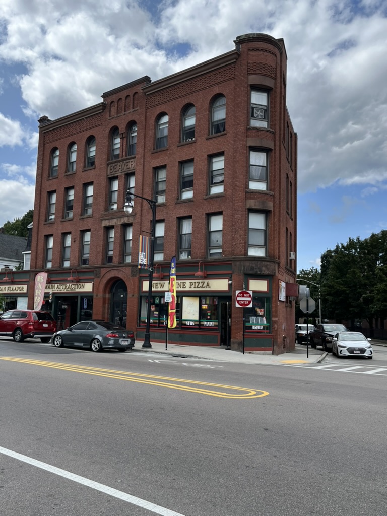
top left: Albion Apartments (1889; WOR.1220), 765 Main Street. top right: Hotel Aurora (1897; WOR.1059), 660 Main Street. middle left: Boynton Apartments (1887-1888; WOR.F), 718 Main Street, one of a series of similar apartment buildings put up in the neighborhood, of which remain: Windsor, next door at 720 Main Street and, one block back on Murray Avenue, Buckingham and Kensington. middle right: Beaver Block (1892; WOR.2450), 974 Main Street, one of the earliest apartment blocks built west of Clark University along Main Street. bottom left: Windsor Apartments (1887-1888), 720 Main Street. See Boynton Apartments above. bottom right (top): Chavoor Buildings (1925; WOR.2428 and WOR.2429), 928 and 930 Main Street, near Clark University. bottom right (bottom): Standish Apartments (1899; WOR.1221), 769-771 Main Street.
*****
Chapter Four: Estate Update

The original congregation in Worcester suffered a fate similar to that of the Baptist congregation. Located two blocks further southwest along Main Street, at the corner of Wellington Street, is an apartment building created around the remains of the shell of the building (whose roof had collapsed in 1978) that once housed the Old South Congregational Church (1888; WOR.1206) after it also moved, in 1889, from its original home for over a century and a half on the site where City Hall currently stands. The apartment building at 714 Main Street retains some of the facade (see photo) of the building that housed what once literally had been the only congregation in town, although by the time the congregation moved to its new location, the impressive building was merely one among many church buildings along South Main Street serving a plethora of religious groups that had sprung up in Worcester over the previous half century.
The original congregation in Worcester first divided, on account of irreconcilable doctrinal differences, into two factions in the 1780s. By 1813 the two “Puritan” churches were joined by a Baptist church and slowly the original “church” in Worcester became just one among many congregations of different denominations in the city. By the 1880s most of the congregation of the Old South Congregational Church had moved out of downtown Worcester, and so the church followed, with the first services held in the new building on January 30, 1889.18See Nutt, Vol. I, pp. 797-803, for a history of Old South Church. Like the nearby First Baptist Church and many other denominations that moved to South Main Street after the Civil War, some of the 1500 members of the congregation (at the end of the First World War) began to move again, away from the changing neighborhood. Finally, in 1965, the congregation of Old South merged with the Tatnuck congregation to become the First Church Congregational, moving to a building three miles northwest of its original home in the center of the city, a physical manifestation of how peripheral the original “church” of Worcester had become.

What remains of Old South Church is located almost exactly one mile from the old Worcester County Courthouse in Lincoln Square, the place from which distances in Worcester County were historically measured. The milestone reading “48 miles from Boston” that is currently in Wheaton Square (see my entry Worcester Part Two) likely was once located a little further along Main Street from Old South, perhaps near the intersection with Oread Street about a quarter mile down the road. At some point during the development of the land along the section of Main Street that formerly comprised the Chandler family estates, the milestone was moved to its present home, opposite what used to be the location of the Worcester Historical Society.19Note that the milestones do not usually measure the distance to Worcester, they measure the distance to Boston. Thus, the Worcester County Courthouse, which is about 46.8 miles from the State House in Boston (although it is listed as 47 miles from Boston on the map of 1795 because the old maps usually rounded to the nearest mile) is about a quarter mile away from the likely original location of the “47 Mile” stone. Thus, although the remains of Old South Church, and the Ward estate upon whose land the church sits, is shown as one mile from the courthouse, the location of the “48 Mile” stone is about a quarter mile further southwest along Main Street, consistent with it being one mile from the previous stone. Confusing? Yes!
Old South Church and all the apartment buildings, commercial buildings, and fraternal organizations along the west side of Main Street are built on land that once belonged to a large estate that lined the west side of the old road from Wellington Street southwest to May Street. On the map of Worcester produced by Stebbins in 1833 the property is owned by “S. Ward” and is located about 1 mile down the road from the old Worcester County Courthouse, as shown on the 1833 map. In 1860 the still large property extends to Piedmont Street but development has begun to encroach upon the edges, and the “Oread Institute” occupies the land between Piedmont Street and King Street. The estate is still the “Wm Ethan Allen Estate” on Triscott’s 1878 map but development lines Piedmont Street as well as a substantial section of the property of the estate that once fronted Main Street. On the 1910 Sanborn Insurance Map, while the house appears to still exist, it sits on only eight remaining acres of land a block behind Main Street while the rest of the land has by then been subdivided and built upon. Old South Congregational Church, the Boynton, the Windsor, and numerous other apartments have been put up along Main Street and most of the modern streets of today’s neighborhood have been pushed through the old estate property. The house was demolished by 1924 after the death of Allen’s son-in-law John Marble in 1921 and a number of apartment buildings (1920s; WOR.ER) were erected on the subdivided lots remaining. Today all that remains of the original nearly 100-acre estate is a two-acre park on Murray Avenue, owned by the YMCA and flanked by Dale, Allendale, and Ethan Allen Streets, the only legacy of the last owner of the greater estate before his heirs began selling off sections for development.20A photograph of the house can be found on the Digital Archive of the Worcester Historical Museum

A typical Boston Rambles entry consists of a description of my efforts to figure out the route and layout of the oldest version of the Upper Boston Post Road and to uncover and to describe as many of the oldest remaining artifacts as possible. In the case of the road out of Worcester, this is difficult for two reasons: the first is that the road was lightly populated in the eighteenth century and the second is that the rapid growth and development along the road after the Civil War erased most of the few old structures that once lined the road. The map of Worcester from 1795 produced by Pierce and Andrews is extremely light on detail; the relatively straight road passes through “empty” countryside until reaching a river some two miles from the center of town over which the “Road to New York” passes on a bridge. After the bridge the road curves slightly before resuming its relatively straight route, passing a tavern en route to the border with Leicester, and that is about it. This entry would be very short indeed if I used that particular map as my template for writing about the road.
There are only two buildings shown along what is today Main Street on the map produced in 1833 by Heman Stebbins (above) from the house of Alpheus Eaton, at the southwestern edge of the more developed area of Worcester at the time (today’s Austin Street, the location of the 6Hundred building), to the first road that intersects with Main Street, what is today called May Street. This 0.6 mile section of road was owned and occupied in the 1830s on both sides by members of the preeminent family of colonial Worcester, the Chandler family. The east side was taken up by the Mower estate as we have seen and as is shown on Stebbins map as “E. Mower,” while the even larger property on the west side is shown on Stebbins’s map as belonging to “S. Ward,” as I mentioned earlier. This is Samuel Ward, who married Sally Chandler, the daughter of Charles Chandler and Sally Mower (also discussed earlier) in 1818, and, “in right of his wife, inherited the large estate of 300 acres formerly known as the ‘Chandler Farm,’ extending west of Main Street from Austin to May Street.”21Caleb A. Wall, Reminiscences of Worcester. Worcester: Tyler & Seagrave, 1877. p. 32. See also p. 65 and p. 70 for more on the property
Ward and his wife moved to Boston in 1837, and the property came into the hands of Abial Jaques, after which it was purchased by Ethan Allen (1808-1871), a gun manufacturer who moved his company to Worcester from Norwich, Connecticut, in 1847. After first moving into a house downtown, he purchased the property here and moved his house from downtown to a new location on this property (see below). Shortly thereafter he built a larger mansion on the hill (shown in this photo) which was demolished in the 1920s as I explained above. The original Chandler farmhouse was also moved (discussed below). Thus the only two houses shown on the map of 1833 are long gone, as are the few other houses beyond the Mower and Ward estates along the road on the Stebbins map.
Thus, this entry, rather than being a search for nonexistent houses along a relatively straight road that has not physically been rerouted appreciably in three centuries, is more about explaining how a relatively simple road out of town developed over the course of more than two centuries to become the complicated street it is today. Phineas Ball in 1860 and Samuel Triscott in 1878 each made an effort to provide an extremely detailed map not just of the center of Worcester but also of virtually every building along two miles of the road from City Hall to Webster Square, detailing the expansion of the city along the old “Road to New York” leading southwest from the historic center. Detailed maps produced in 1910 for the Sanborn Insurance Company exist for virtually every building along Main Street almost to the junction of Apricot Street, where the original road left Main Street and continued on to Leicester. Examining these excellent maps and showing the changes over time at different locations along the road is a way to take advantage of the remarkable and unusually detailed resources that are available to me along this short stretch of the road. After all, this project, while principally focused on uncovering the oldest route of the Upper Boston Post Road, is also an attempt to provide a portrait of the contemporary road. In this case I am fortunate enough to have material that allows me to show in some detail exactly how the road changed over time.

Ball’s map of 1860 (see below) shows that the old estate on the west side of Main Street, now owned by Ethan Allen, is still largely intact although there had been a bit of nibbling at the edges since 1833. There is substantially more development shown on the map along the eastern, or Mower, side of the street, although the Mower house and surrounding area are not yet developed. Even in 1878, as shown on Triscott’s map, both the Mower estate and what is now called the “Wm Ethan Allen” estate are still in possession of large amounts of land, although there is much more development along the road than there had been twenty years earlier. Most of the development shown on the map along Main Street in the area is residential. One particularly interesting building along what was once the Chandler, then the Ward, then the Jaques, then the Allen estate, is the house still located at 770 Main Street. The Dowley-Taylor mansion (1842; WOR.1802) was built on a lot near City Hall in 1842 by Levi Dowley, a shoe and leather merchant. According to the report on the MACRIS database “Dowley suffered financial failure in 1847 and was forced to sell his house to Ethan Allen, a gun manufacturer. In 1853 Allen responded to the growing commercial value of the house’s original site by selling the land and moving the house to its present site south of the business district. Allen lived briefly in the house. Other owners included Jonathan Grout, Dr Frank H. Kelley (onetime Mayor of Worcester); the house was purchased by Ransom C. Taylor in 1882. In 1952 the last of Taylor’s descendants to live in the house sold it and in 1957 Worcester Junior College converted it to classroom use.” The house is shown on Triscott’s 1878 map as owned by “F.H. Kelley,” and Ransom Taylor is the real estate mogul discussed in the previous entry.
The Dowley-Taylor mansion continued as part of Worcester Junior College, which was affiliated with the neighboring YMCA. The YMCA was another of the institutions that, in 1924, relocated from downtown to a building at 766 Main Street (1917; WOR.1195). The YMCA recently demolished the 1917 building that once fronted Main Street and built a newer, more modern building set back from the street, but the college in the old Dowley-Taylor mansion has long since closed. Today the mansion serves as the headquarters of the Worcester Head Start program, yet another piece of Worcester’s rich architectural heritage being used for purposes for which it is patently not suited. On Ball’s map of 1860 the house is the only building shown on the west side of Main Street from Wellington Street to Piedmont Street. By 1878 there were two properties north of the house and four buildings south of the house lining Main Street to the intersection with May Street. The Moody-Shattuck-Edson House (1885: WOR.1812), located at 768 Main Street between the YMCA and the Dowley-Taylor Mansion, was also part of Worcester Junior College at one point, but today is the Garvey Parent Information Welcome Center for Worcester Public Schools, another interesting and, in my opinion, inappropriately-utilized building. One other house remains, at 776 Main Street, the Sullivan and Nettie Forehand House (1866; WOR.2879) built for Sullivan Forehand, the foreman of the Ethan Allen Company, and his wife Nettie, Ethan Allen’s daughter. By 1910 the building had become a boarding house, operated by an Armenian immigrant, Garabed B. Thomajian, illustrating, in the words of the historic structure report “the displacement of more genteel families to newer residential areas on the fringes of the city…and the growing role new Armenian and Jewish speculators were developing in Worcester real estate.” Just beyond the house, which today appears to be a well-kept Second Empire apartment house, is a storefront church, the Iglesia Christiana La Hermosa, before reaching Piedmont Street, the boundary of the Allen estate on Ball’s 1860 map.

The Mower Estate and the Allen Estate are long gone. The oldest building still standing in its original location along the old road from City Hall to the border with Leicester is the Third (or Main Street) Baptist Church building at 717 Main Street, built in 1855 as part of an early wave of growth along Main Street just before the Civil War. Most of the pre-Civil War history of the Upper Boston Post Road has been completely built over in successive stages of expansion. There are no buildings along the route from the eighteenth century as far as I have been able to ascertain, and the oldest building along the road I have been able to verifiably date is the Dowley-Taylor mansion, built in 1842, with the caveat that it was moved in 1853 to its current location at 770 Main Street from its original location downtown. Ironically, there is a building that dates to at least 1812, the oldest extant building along the route of the Upper Boston Post Road from City Hall to Leicester, but it is not located on Main Street at all as it too was moved (twice!) and now is located along Mill Street overlooking Coes Reservoir. I will discuss the Stearns tavern when I reach the original site of the building along the road in the next entry, but the fact is that this walk has no real colonial landmarks, and the lion’s share of the architecture along the road dates to the post-Civil War period.
Just across Main Street from Old South is the Charlton (1914; WOR.2388; 703-711 Main Street), a yellow brick building with commercial spaces on the ground floor and a “lodging house” on the upper floors, a notably less grand building than the nearby Boynton or Windsor buildings of thirty years earlier, when the neighborhood was more aspirational. Next door is what might be the oldest building along the road as discussed above, the Norman-style Emmanuel Third Baptist Church (1855; WOR.1194, see photo), on the corner of Hermon Street at 717 Main Street. It was put up in 1855, so that at least counts as before the Civil War. The Third Baptist Church is visible on Phineas Ball’s detailed map of Worcester from 1860, directly across the street from the Allen estate and on Triscott’s map of 1878 as the Main Street Baptist Church (they changed the name in 1864). This “second colony” (after the formation of the Second or Pleasant Street Church in 1841) was formed in 1852. As discussed earlier, the congregation of the First and Third (or Main Street) churches merged in 1902 and this building was sold to the First Presbyterian Church of Worcester, which is what the building is labelled as on the Sanborn Map of the area (Vol III #241). The building became a Baptist Church again when it was purchased by the congregation led by the Reverend Richard Wright, who founded the Emmanuel Baptist Church in 1976, and the congregation moved into the building shortly thereafter.

In case the reader is beginning to despair that this entry is an ecclesiastical history of Worcester in disguise or that I am searching for the Sunday service that best suits my needs, rest assured that there is a purpose to these somewhat detailed histories of the peregrinations of various congregations in Worcester. The original church in Worcester was essentially the church of the state. The first meeting house on the Common was erected in 1719 and remained the only “church” in town until the long-simmering feud between the more conservative Calvinists and the more liberal “Arminians” broke into the open in the 1780s, leading to the division of the congregation and the formation of the First Unitarian Church, which established a separate building in Lincoln Square (see the Worcester Part II entry). The establishment of a Baptist Church in 1813 marked a further blow to the hegemony of the Congregational church in Worcester. By 1848, the “original” church had a lot of competition: in addition to the various branches of the Congregational and Baptist churches there was also St John’s Catholic Church, a Methodist church, a Universalist church, a Quaker meetinghouse, and “one or two societies of colored persons.”22Albert Southwick, 150 Years of Worcester: 1848-1998. Worcester: Chandler House Press, 1998. p. 3.
Churches of all varieties continued to proliferate along Main Street as the population of Worcester expanded and many of the buildings that appear on the Sanborn Insurance maps produced in 1910 still exist. These buildings serve as a sort of unofficial symbol of the arrival of different groups in Worcester with sufficient numbers, money, and clout to erect a building in which to worship. Following the evolution of these buildings as I walk along Main Street is a shorthand way of describing the demographic changes along the road and, by extension, in the city of Worcester as a whole. Incidentally, churches continue to pop up along the road, and it is not just church buildings that change hands between various denominations; as we shall see, many of the newer churches are “storefront churches,” setting up business inside old commercial or institutional buildings, like the aforementioned Ebenezer Church or La Iglesia Christiana La Hermosa.
*****
Photo Gallery: Ecclesiastical Buildings Along South Main Street in Worcester


This is a gallery of ecclesiastical buildings encountered on the walk along the Upper Boston Post Road in Worcester southwest from City Hall through the Main South neighborhood. Most of the buildings were built specifically for various denominations who moved out of downtown in the late nineteenth century; some have been taken over by different denominations over time, while others are no longer used for religious services. There are also a number of “storefront churches,” located in commercial spaces along Main Street, typically catering to a Latin American immigrant congregation.
The buildings* in the gallery are listed as follows: first row (left to right): Emmanuel Baptist Church (1855), 717 Main Street; Old South Congregational Church (1889), 714 Main Street; Pilgrim Congregational Church (1887), 909 Main Street; second row left (top): Disciples of Christ (1885), 829 Main Street; second row (bottom): South Unitarian Church (1894), 886 Main Street; second row right: St. Peter’s Roman Catholic Church (1888), 935 Main Street; third row left: First Church of Christ Scientist (1914), 880 Main Street; third row right: St. Mark’s Episcopal Church (1888), 6 Freeland Avenue (behind the parking lot next to the McDonald’s at 995 Main Street.
* Note this list records the original congregation for which the church was built. For changes to the individual congregation in the building over time see the discussion in the main entry.
*****
Chapter Five: Liminal Space. Mile 49. Getting Out of Downtown.
It is not just old houses that have vanished from the area over the past two centuries. The old road is shown crossing a small brook just beyond the Ward house and the Mower house on the 1833 map of Heman Stebbins; on Phineas Ball’s 1860 map the vestigial remains of the brook can be seen flowing southeast between Hermon and Jackson Streets, just past the Third Baptist Church. By 1878 the only water shown on Triscott’s map are two small ponds on the Allen Estate, while on the Sanborn map (#241) from 1910, the brook and the ponds have disappeared, presumably channeled through underground conduits.23One tiny pond still survives in 1910, shown on Sanborn Vol II, map #39, behind 766 Main Street, but today even that is gone. Stebbins then shows the road climbing a small incline before reaching a plateau, along which the road continues for another mile. There are only four houses situated along the road as it crosses the plateau before it descends into the valley where New Worcester was developing.
The first building shown on Stebbins’s 1833 map of Worcester beyond the Mower and Ward estates is the house at the southwest corner of what is today Main Street and May Street, listed on the map as the house of “Wm. Stowell.” Caleb Wall reports, in his 1877 Reminiscences of Worcester, that “on the south corner of Main and May streets is an ancient dwelling, at least one hundred years old, the original farm-house of the Chandler (later Ward-Jaques-Allen) estate, which was removed from its original location upon the Ethan Allen estate in 1832 by William Stowell, building mover, who occupied it for a few years upon its present site before he purchased the Alpheus Eaton estate on the corner of Main and Austin streets.”24Wall, p. 262. The house, which is long gone from this location, was likely the oldest building along this section of the route of the Upper Boston Post Road. Like many of the older buildings discussed in this entry, it was physically moved from its original location to a new location along Main Street and, although unlikely, might have been moved again as it is no longer found on the corner which today is occupied by a modern one-story commercial building at 848-852 Main Street, housing a barber shop, Kumasi African supermarket, an African braiding and hair salon, and a Puerto Rican mofongo restaurant. The man who moved the house, William Stowell, later moved to the house of Alpheus Eaton, the house discussed earlier at the corner of Main Street and Austin Street, located where the 6Hundred building currently sits, a building very unlikely to be moved.

Although the old buildings have mostly disappeared or been moved in and out of the area, footprints of some older buildings and developments on the maps linger. On a hill behind Main Street, between Castle Street and Oread Street, is the small Oread Castle Park, which was once the site of the Oread Collegiate Institute, an early women’s college opened in 1849, one of the few institutions of higher learning open to women. The college building was built along the “lines of a medieval castle…with circular towers fifty feet in diameter,” and it housed the college for 32 years, until the death of the son of the founder; eventually it became a riding school and was eventually demolished.25See Nutt, Vol. II., pp. 734-736. The towers of the Oread Institute can be seen on Ball’s 1860 map. By 1878, the property fronting Main Street and the streets leading up to the Institute had been developed into row houses.
Main Street, from the Worcester Market building to the area around the Oread Institute, is a liminal space; it is neither downtown nor is it fully a residential area. It is technically part of the Main South Community Development map but feels and looks on the map like an appendage to the larger neighborhood to the southwest. It is at the intersection of three zip code zones and of three census tracts. Almost none of the walk in this entry is in an area that was officially “red-lined” on the 1936 map. In part this was because Main Street, from City Hall for more than half a mile, almost to May Street was considered to be a part of downtown Worcester by the 1930s. This first section of the walk along Main Street, through the area shown on the 1833 map as the rural estates of Samuel Ward and Ephraim Mower, to Castle and Oread Street (the names of streets change as they cross Main Street), was technically marked as the “Business District” on the 1936 maps. After an initial burst of residential development before the Civil War, such as the houses built in the 1840s and 1850s along Sycamore Street, the few old houses that remained along Main Street began to be replaced beginning in the 1880s more and more by apartment buildings and hotels, like the Standish Hotel (1899; WOR.1221; 769-771 Main Street), where Sigmund Freud stayed while in Worcester for his famous series of lectures at nearby Clark University (discussed later) and, my personal favorite, the Albion Apartments (1889; WOR.1220; 765 Main Street). See the photo gallery above for images of these two apartment buildings and more along Main Street.
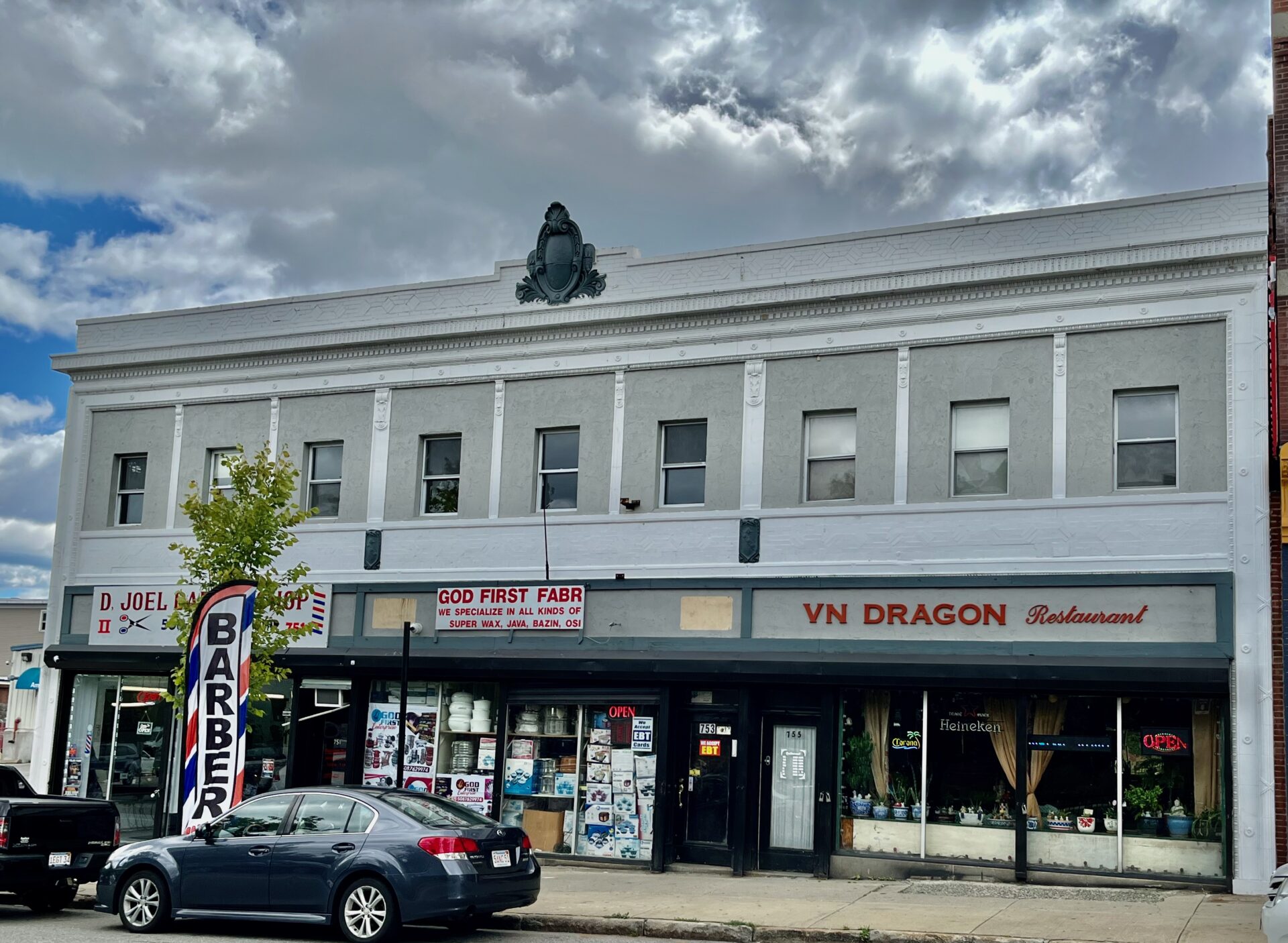
However, by the early twentieth century commercial construction continually expanded downtown along Main Street, exemplified by the Worcester Market building and the Sears Roebuck building. These early endeavors were joined by businesses in a newly established commercial trade devoted to the sale and repair of a new form of transportation, the automobile. The edge of downtown, particularly along Main Street, became a center of the automobile trade. The building at 751-755 Main Street that today houses a Vietnamese restaurant, a barber, and an Afro-Caribbean market was originally built in 1917, likely from a design by Oreste Ziroli (who also built the Worcester Market building), as an automobile showroom for the F.S. Howard Motorcar Company (1917; WOR.2102; 751-755 Main Street). According to the historic structure report for the building on the MACRIS website “twelve of the fifty ‘automobile’ listings in the 1916 Worcester Directory were in the area between 652 and 677 Main Street.” The automobile-related businesses continued to expand southwest along Main Street, where they continue to exist, albeit in less glamorous buildings. At 783-795 Main Street, another brick building fronted by a cast stone facade designed to imitate limestone, also once served as an automobile showroom (1925; WOR.2108) but now houses an African market and a Latin-themed restaurant called Sazon Bar & Grill. There is an early gas station building at 779 Main Street (1948; WOR.2106) that today houses Mia’s Auto Sales, a business which also has taken over the southwest corner of Piedmont Street, a now soulless location where the Piedmont Congregational church (1877) once stood, as shown on Triscott’s 1878 map above. Both of the former automobile showroom buildings can be seen in the photo gallery below devoted to commercial buildings. It is probably reasonable to conclude that long-time residents of the changing neighborhood purchased cars from these nearby establishments enabling them to move to newer “still desirable” neighborhoods further out of town.

Piedmont Congregational Church, named because it was located at the foot of the hill on which the Oread Institute once stood, is the last building on Main Street still located in the “Business District” on the 1936 “residential security area” map produced for the Homeowners Loan Corporation (HOLC). Perhaps not coincidentally, also in 1936, the congregation of Piedmont Church merged with the Plymouth Congregation and the Union Congregation and moved to the Chestnut Street Church in a “blue-lined” or “still desirable” neighborhood near WPI on the north side of downtown.
Although the “red line” on the 1936 map was less than a block away to the southeast, Main Street never technically passed through a red-lined district. Thus the photograph of dilapidated houses along Castle Street at the beginning of the Worcester Business Journal (WBJ) article on redlining is misleading as the street was NOT in a red-lined area (see my photo at left of the same houses).26It turns out that, based on the Main South Community Development Corporation map (see below), these buildings are not technically in Main South either, the area that is the putative focus of the article. The border of Main South incorporates Oread Castle Park and the line runs down Castle Street but does not include the houses in the photograph on the north side of the street, a minor technical point but again one that undermines the overall argument- if your data is for the wrong neighborhood, if the neighborhood being discussed was not actually red-lined, and if the photo is of buildings not technically in the area under discussion, it makes the rest of the article suspect. It was, however, the first street in “yellow-lined” area 9 (see HOLC map above), which was the color chosen to represent a neighborhood that was considered to be “definitely declining.” The entire area north of Main Street that was not in the narrow “Business District,” including most of the Allen Estate all the way to its original western boundary at May Street, was “yellow-lined,” as was everything on the south side of Main Street from Castle Street and Oread Street west all the way to the border with Leicester.
It probably was not difficult for the HOLC surveyors to conclude that the neighborhood was declining in the 1930s. The mere fact that commercial establishments like automobile showrooms were popping up along Main Street rather than the large apartment buildings of a few decades earlier is a clear sign that the priorities of developers had changed, and the housing stock in the area was beginning to decay. In their description of area 9, the yellow-lined district whose eastern boundary was at Castle Street, the surveyors reported “In the eastern section three-decker houses predominate, many of which are 40 years old or more, and in a poor to fair state of repair.” The row houses along Castle Street shown in the photograph in the WBJ article were part of the earliest wave of residential developments along Main Street, with the first building put up by the builder Lakin Gates beginning in 1868 and continuing through the 1870s (1868; WOR.2882/ WOR.2883; 798-800 Main Street and Castle Street). Construction was financed by Eli Thayer, the founder of the Oread Institute, and the houses were built in the shadow of the college on the hill on property he sold to help liquidate a mortgage on the Institute.

It is not hyperbole to say that this block is almost as dispiriting as the block around the Worcester Market building. The row houses described in 1936 as being “in a poor to fair state of repair” are in many cases in a worse state of repair today (see photo), with some missing entrance staircases for example. One or two of these architecturally quite interesting buildings have been restored by appreciative owners, but the neighborhood itself is unpleasant, with abandoned buildings, empty lots, few useful businesses, and more than a few troubled-looking people hanging around on street corners. As I make my way down Oread Place after visiting Oread Castle Park I am obliged to cross the street to avoid a crowd of people sprawled on the sidewalk in what appears to be an open-air drug market. A stray shopping cart sits in the middle of the street which is strewn, along with the sidewalk and the empty lot at the southwest corner of Oread Place and Main Street, with potato chip bags, candy wrappers, fast food containers, empty beer cans, bottles of energy drink, those ubiquitous plastic “nip” bottles, and soiled blankets. Facing me as I make my way down Oread Place, in the middle of another empty lot directly across Main Street at the corner of Benefit Street, is a large sign proclaiming, seemingly without irony, “I ❤️ MAIN SOUTH.” The sign was thankfully gone on my most recent trip through the neighborhood, and a construction project was beginning on the site to build low-income housing, perhaps destined for some of the people who seem to live around the trash-filled lot across the street. This area is likely the original location of the “48 Mile” stone now sitting in Wheaton Square; it seems the stone decided to move out of the neighborhood along with the early residents.

*****
Despite yet another dispiriting encounter with troubled people on the street, the neighborhood overall is in better shape than it had been just a few years previous to my recent visits. One of my favorite apartment buildings, as I mentioned earlier, along the route of this walk is the Albion Apartment nearby at 765 Main Street (see photo gallery of apartment buildings). This elegant and imposing five-story Romanesque Revival building is one of the nicest looking of the wave of new apartment buildings that swept along Main Street in the 1880s and 1890s. Unfortunately, in recent years it had become a “blight on the landscape” and a “symbol of skid row,” according to an article in the Worcester Telegram from 2019. The article also states that “in January 2014 the rooming house was the scene of a homicide in which a security guard at the building was charged with fatally shooting a custodian. (Worcester City Councilor) Barbara Haller said more than 1,500 police calls and more than 400 ambulance calls were made to the building between 2013 and 2016. ‘I heard every hallway was trouble,’ said Mandy Anderson, 42, a tenant the past two years who works the front desk and does housekeeping at the Albion. ‘All drugs, all trouble.'” Not only were there 84 code violations in the building in an 18-month span, the second most in the city, there were 11 drug overdoses in the building in 2017 alone. A recent change in ownership and stricter rules about behavior have apparently dramatically reduced, but not eliminated, problems in the building, which had zero code violations and one victim of a drug overdose in 2018, according to the article in the Telegram, entitled Night and Day. A similarly glum story about the neighboring Standish Apartment building, also on the rebound after a checkered recent history involving multiple fires, contamination from asbestos, vagrants, and vandals, appeared in the Telegram in 2024. As an outsider wandering through the neighborhood, it can look like things could not get any worse, but they have in fact improved in recent years.
A number of the nineteenth-century houses that remain along Main Street were disfigured in the early twentieth century in a manner that frequently obscures some otherwise quite interesting buildings. The Lakin Gates row house, discussed earlier, at the southwest corner of Castle Street and Main Street, and the Merriam & Woodward Double House (1882 with 1923 addition; WOR.2880) at 790-796 Main Street on the northeast corner of Main Street and Castle Street both have, in the words of the historic structure report “one-story extensions built from the front facades of the houses to the edge of the side walk to create store fronts and entries for commercial spaces that then extended back into the main floors of the houses.” Each of the individual units of the “double house” was originally owned by a pair of bookkeepers (named Henry Merriam and William Woodward), who later rented the house, and by the 1920s it had become a boarding house. The building was sold to an Armenian developer named Albert Chavoor in 1924, who, according to the historic structure report, “added the brick storefront. Armenians were not living in this area of Main Street but many were investing in transitional residential properties and converting them to commercial functions which they managed, including shoe repair, barber shop, provisions etc.” Today the commercial front, which obscures the vinyl-sided Victorian behind it, houses a “Rent-a-Center.”

Many other buildings along Main Street, including the once-lovely High Victorian Gothic Addison Macullar House (1876; WOR.1132; 2 Oread Street) across the street, suffered a similar fate. Many of the commercial spaces today are filled with small businesses typically run by immigrants to Worcester, who make up a large fraction of the total population in the neighborhoods along Main Street southwest of City Hall, businesses that include barber shops, restaurants, markets, and even storefront churches. The rare intact Victorian building is often occupied by a commercial business as well, such as the Second Empire Lucius Knowles House (1870; WOR.1808) at 838 Main Street, which is today a funeral home. Across the street is the Mark (1909; WOR.2389; 833 Main Street) another of the early apartment buildings, and nearby is another example of the fine collection of late-nineteenth century church buildings that line Main Street, this one originally built for a congregation called the Disciples of Christ (1885; WOR.1136; 829 Main Street, see photo gallery), but today the home of the Iglesia Pentacostal Roca de Salvacion, one of many evangelical Hispanic congregations that have largely supplanted the old English-speaking congregations for whom the churches were originally built.
*****
Chapter Six: Opening the Flood Gates
The busy intersection of Main Street, May Street, and Hammond Street is filled with modern commercial buildings, including a large Family Dollar and accompanying parking lot, a Dunkin Donuts, a used car lot, and the building standing on the site of the Chandler farm house which, as discussed earlier, was moved to the southwest corner of Main Street and May Street in 1832 by William Stowell. May Street is about a mile from Worcester City Hall and on Stebbins’ map of 1833 is shown as the boundary between the “School District,” i.e. the central district of the town of Worcester, and the outlying “District 3,” one of 11 districts surrounding the densely-populated center, called the “skirts” in the nineteenth century.27Kenneth J. Moynihan, A History of Worcester, 1674-1848. Charleston: History Press, 2007. p. 117. Although the area further west, around “New Worcester,” is somewhat developed on the 1833 Stebbins map, there are only three houses (not counting the old Chandler farmhouse/Stowell house) shown between May Street and Beaver Street, the next road on the map intersecting with Main Street, a distance of 0.6 miles. Today this is a densely populated neighborhood surrounding Clark University.
Despite the inauspicious start to this section of the walk in the area officially no longer considered “downtown,” the neighborhood around Clark is in slightly better shape than the “downtown” section of Main Street that I have walked along thus far, although there are still a few buildings that have seen better days, a few empty lots, and more modern commercial developments with affiliated parking lots, probably the clearest sign that this is the more “suburban” part of Worcester. Aside from this busy intersection, the road is relatively peaceful and easy to walk, with frequent crosswalks and wide sidewalks on both sides of the street. The area is not scarred by the intrusion of the interstate highway, and Main Street, although busy with traffic, is thankfully only a two-lane road. The majority of the buildings along the road are late-nineteenth and early-twentieth century houses, some with the commercial storefront additions described earlier, but a few of the large Victorian houses along the road seem to be well-cared-for single-family residences, a notable change from the first section of the road from Austin Street to May Street.

Before wandering down Main Street I take a short detour along Hammond Street to visit Miss Worcester Diner (a ten-minute walk away, on Southbridge Street). On the way I pass a building at the top of the hill that is purportedly the house of Benjamin Butman (1828; WOR.1330; 14 Hammond Street), a house which was moved to this location from its original location on Main Street across from City Hall sometime around 1880 by Joseph Sargent. Unfortunately, whatever original building still exists is buried under the heavily reconfigured current structure, and it is difficult to identify any of the features seen in the image, shown in the previous entry, of the view along Main Street in Caleb Wall’s 1877 book Reminiscences of Worcester (it is the first building on the left in the image). In what is the theme of this entry, I have once again encountered a building in the running to be the oldest building in the area along this section of the walk which has been moved from another location and, in this case, has been so heavily altered as to be unrecognizable. At least it is, in theory, still extant, though hidden under the changes, unlike the Mower or Allen/Chandler buildings, which were demolished.
So I return to Main Street and keep moving along the “road to New York,” a road which, from May Street to Beaver Street, sits on a plain about 520 feet above sea level in elevation and so is relatively flat and straight for the next three-quarters of a mile, with occasional views south over the valley across to the hills a mile away where the College of the Holy Cross is located. Holy Cross was established in 1843 as the first Catholic College in New England, after Bishop Fenwick’s plans for a similar institution in Boston were thwarted by opposition from Protestant leaders.28See my entry Foreign and Familiar for more on nativist hostility to Irish Catholics in Boston. This section of the walk passes through an area lined with connections to the Catholic Church, starting with the Catholic Charities Distribution Center located up the hill off Hammond Street, behind St Peter’s Central Catholic School. A little further down the road, close to Clark University, is St. Peter’s Catholic Church, a grand edifice located two miles away from St. John’s Catholic Church, the first Catholic church in Worcester, built on Temple Street next to the railroad tracks in the industrial and working-class Canal District, but many miles away in terms of economic and social status.
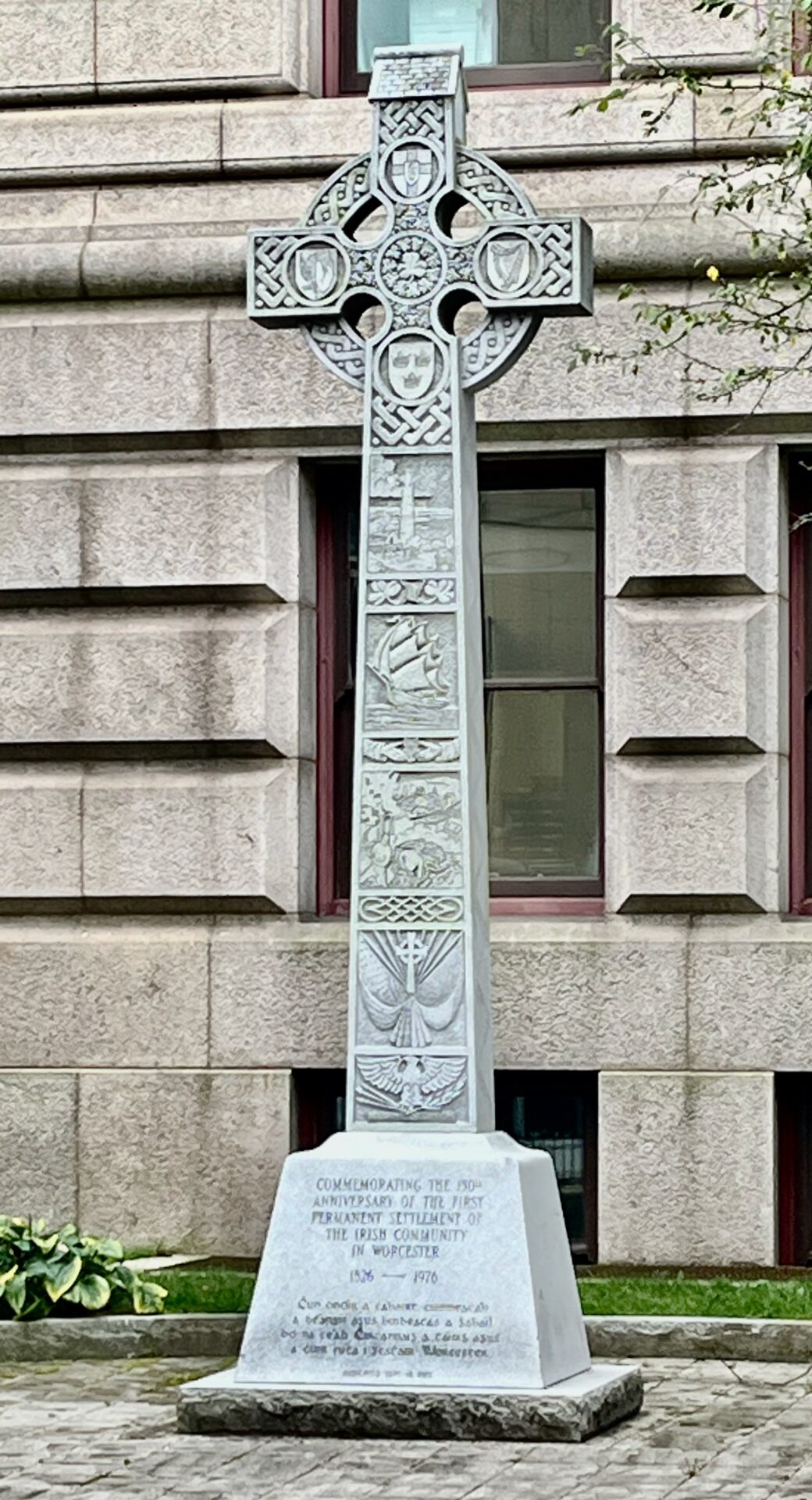
The first significant population of Irish immigrants arrived in Worcester on July 4, 1826 to finish the construction of the Blackstone Canal, according to historian Kenneth Moynihan.29Kenneth J. Moynihan, A History of Worcester, 1674-1848. Charleston: History Press, 2007. p. 125. The slow progress of the project to create a “port of Worcester” connected to the sea at Providence, Rhode Island by a canal linking up with the Blackstone River resulted in the hiring of Benjamin Wright, chief engineer of the recently completed Erie Canal in New York, who brought with him contractors who “were all Irish with experience of canal building in Britain.”30Moynihan, see pp. 132-140. The completion of the canal stimulated businessmen in Boston who, fearing the loss of trade from the hinterlands of Massachusetts through an alternative port in Rhode Island, planned and began construction of a railroad from Boston to Worcester in 1831, which opened on July 6, 1835. According to Moynihan “the railroad connection was the first of many that gave Worcester greatly improved access to raw materials and markets and, in doing so, launched it definitively on its career as a major inland manufacturing center.”31Moynihan, p. 136. It also was the final blow for the canal, which promised more than it delivered and was subsequently filled in. Although neither the Blackstone Canal nor the railroad cross paths with the route of the Upper Boston Post Road in Worcester, the streams leading into the Blackstone Canal and the Blackstone River do cross the road, and the impact of the canal and the railroad on the history and development of Worcester has significantly affected the development of the road.
The website of the Blackstone River Valley National Historical Park succinctly summarizes the early importance of the river: “At first glance, the Blackstone River seems completely ordinary. It is not very long or very wide. But along the banks of the Blackstone, the American Industrial Revolution was born, and the Blackstone became known as America’s ‘hardest working river.’” The Blackstone Heritage Corridor is an integrated cultural and natural landscape that begins in Worcester and follows the 48 miles of the Blackstone River as it drops 438 feet to sea level.” The river was important for two reasons, both as the first major site of industrial activity in America at Slater Mill in Pawtucket, Rhode Island, the influence of which quickly spread to Worcester and its many hills and valleys lined with streams and brooks, but also because of the demands of transport. According to the National Park Service website: “in conjunction with the Industrial Revolution was the need for a transportation revolution to cheaply and efficiently move heavy cargo between the mills on the river and the port of Providence. The river itself was impassible to large boats, and horse drawn wagons were too slow and expensive. The first solution was the construction of the Blackstone Canal in 1824-1828. The canal was faster than roads, but more importantly much cheaper. Each canal barge could haul 30-35 tons of cargo pulled by only two horses. The canal, though an improvement was still flawed, and it was not until the coming of the railroad that the Industrial Revolution exploded throughout the Blackstone Valley and America. The Boston to Worcester line in 1835, followed by the Providence and Worcester line in 1847 allowed for the fast, cheap and reliable transport of raw materials, finished goods and farm products between the villages of the Blackstone Valley and the ports of Providence and Boston. Rail service also made practical the conversion of the textile mills of the valley from water power to steam power by the 1860’s and 1870’s.”
The railroad, like the canal, was built largely by Irish laborers, many of whom settled in Worcester, leading to ethnic and religious tension with the overwhelmingly Protestant native population.32Moynihan, p. 107. Green Street, near the railroad and the canal, became the center of the Irish population, “including in 1832, Christ Church, the first Catholic house of worship in western Massachusetts…St. John’s Parish, which registered over 300 adult members in 1840, moved its worship services in 1845 from the inadequate Christ Church structure to the new St. John’s Church, which still stands on Temple Street.”33Moynihan, p. 137. By 1845 the Irish population in Worcester had increased to 600 residents, but it exploded after the Irish famine to over 3,200 only five years later. By 1895, among Worcester’s more than 100,000 inhabitants, there were 11,371 foreign-born Irish residents, a number which does not include the many people of Irish descent born in Worcester or in the United States living in the city.
By 1900, Worcester had firmly become a city of immigrants, with foreign-born residents making up more than a third of the entire population and more than half of all school children.34For more on immigrants to Worcester in the nineteenth century see Albert Southwick, 150 Years of Worcester: 1848-1998. Worcester: Chandler House Press, 1998. The Catholic Church, once a controversial and unwanted addition to the religious and cultural scene in Worcester, is now the largest single religious denomination in Worcester County. The Diocese of Worcester, created in 1950 from the Diocese of Springfield, comprises all of Worcester County and contains, according to its website, 89 parishes, three missions, three Catholic colleges, five private Catholic high schools and one public diocesan high school, thirteen elementary schools (including St. Peter’s), and, with a resident Catholic population of 266,700 (although how they came to this number is a mystery), a third of the entire population of the county.
St Peter’s Central Catholic School (1919; WOR.2390; 865 Main Street) was merely one of a number of additions to the holdings of the church along South Main Street. According to the Preservation Worcester report on the building “the Archdiocese of Springfield was purchasing the aging mansions along Main and Ripley Streets to provide for the religious community centered in St Peter’s Church, located about five blocks away, and expand its educational and social services.” The first of these buildings acquired by the archdiocese was “the old Ripley mansion” located behind the site that would become the school, a house which was used as a convent for the Sisters of St Joseph. The “Ripley” house, according to Caleb Wall in his Reminiscences of Worcester from 1877, was the “residence of the late John C. Ripley, and was the dwelling as early as 1760, of Ebeneezer Wiswall…and next, of Ebeneezer Collier, the last occupant before Mr Ripley.”35Wall, p. 262. There is only one house shown on the Stebbins map of 1833 in the area, set back from Main Street, along a path leading uphill which corresponds to today’s Ripley Street, with the owner/occupant listed as “E. Collier.” Thus the Ripley house is likely the same house as the Collier house shown on Stebbins’s map.
As late as 1860, on Phineas Ball’s map of Worcester, there is still only a single house along the east side of Main Street, from May/Hammond Street all the way to Beaver Street. The house is set back from the road on the hill to the south, directly opposite the newly built Claremont Street, a location consistent with it being the Collier house, presumably owned by John C. Ripley. Triscott’s map (1878), produced almost twenty years later, shows substantially more development in the area. Not only has Ripley Street been created, the entire block, from Hammond Street to Ripley Street and from Main Street east to Beacon Street, has been subdivided into various lots and new estates. The large estate of Joseph Sargent is visible on the map. Sargent moved to a newly-built house on this property from the house he formerly inhabited near City Hall originally built by Benjamin Butman, the house that itself was subsequently moved to this property in 1880. Also visible on the map are the estates of Charles Barton, treasurer of Rice, Barton, and Falen Machine & Iron Company, and of Joseph H. Walker, partner in J.H. & G.M. Walker Boot Manufacturers. Ripley’s mansion on the Triscott map is occupied by A.E. Quackenboss, on a substantially smaller plot of land than the massive property of twenty years earlier, which was broken up around the time of Ripley’s death in 1869, the year both the Walker and the Barton houses were built.

According to Charles Nutt in his History of Worcester and Its Peoples, published in 1919, “the estate of the late Hon. Joseph H. Walker, at Main and Ripley Streets, was bought December 16, 1916, for parochial school purposes.”36Charles Nutt, The History of Worcester and Its Peoples, 4 Volumes. New York: Lewis Historical Publishing Company, 1919. Vol. II, p. 875. St Peter’s School was built on the Walker estate in 1919, on the northeast corner of Ripley Street and Main Street, and opened in 1921, sharing the promontory with the Barton estate “until the Springfield Diocese bought the estate from the Barton family in 1946 and demolished the building…later a second school building was built on the site of the Barton house,” according to the Preservation Worcester report. Today the school, once a high school but now a K-8 school, shares space with Catholic Charities of Worcester, which has a large building located on the site of the old Ripley House behind the school. As the Preservation Worcester report notes, St. Peter’s School “remains as a landmark of the dramatic growth and transformation of south Main Street in the early twentieth century.” The school itself acknowledges this transformation on their website, stating “our presence in the Main South, inner city section of the city is strongly respected.”
The rapid growth of the Catholic population enabled the church to establish new parishes in Worcester in the latter half of the nineteenth century, particularly as there were other immigrant groups that were also predominantly Catholic, including French-Canadians, Poles, and Italians. As I discussed in the previous entry, a new diocesan Cathedral of St. Paul was opened in 1875 overlooking City Hall, a symbol of the increasing influence of the Irish and other immigrant communities in Worcester. St Peter’s Parish was organized in 1884 as the first parish in the west part of the city. Construction began on St. Peter’s Church (1889; WOR.1277; 935 Main Street) in 1889, and the church was dedicated in 1893, joining the many other congregations moving to the growing neighborhoods along South Main Street. As the only non-Protestant denomination among the many new churches built along Main Street in the decades after the Civil War, St. Peter’s Catholic Church was the earliest building signifying the arrival of immigrant populations to the area, a harbinger of the diversity that is now the hallmark of Main South.
*****

*****
Chapter Seven: Seeing the World along Main South
The buildings lining the five blocks along Main Street between St. Peter’s School and St. Peter’s Church, directly across the street from Clark University, which opened in 1889, are as good an example as any to illustrate the story of Worcester during the last 150 years. As I mentioned earlier, both Heman Stebbins on his 1833 map and Phineas Ball on his 1860 map showed only a single house on the east (the left-hand side of the road if heading out of town) side of Main Street from Hammond Street to Beaver Street (which today is effectively the southwestern edge of the Clark University campus). There were about a dozen houses spread over a half-mile along the west side of the road (the right-hand side of the road if heading out of town) on Ball’s map by 1860, and most of the roads leading off of Main Street today had by then already been laid out. On the map of 1833, by contrast, the estate of “H. Heywood” is the lone property shown on the west side of the road between the Stowell/Chandler farm house at the corner of May Street and the beginning of the New Worcester area well beyond Beaver Street. By 1878 the blocks were filling in with lots, some developed, others soon to be developed. I record sixteen lots, with five houses built, on the east side of Main Street on Triscott’s map, while the west side had fourteen lots directly on Main Street, with eight houses shown along the five blocks from May Street to Downing Street (today part of Woodland Street) at what was to become the eastern edge of the Clark University campus, with an additional four lots and one more house between Downing Street and Beaver Street.
Some of these houses, such as the house listed on Triscott as the “C. Taft” house on the corner of May Street and Main Street (which was the Chandler farm house owned by William Stowell in 1833) are very old and none of the oldest houses shown on the 1833 Stebbins map exist today, with the exception of the Stearn tavern (to be discussed in the next entry). Is anything left from the Triscott map of 1878 or from the Ball map of 1860, something to at least push the road back to the period around the Civil War? It turns out that there are a few buildings precariously clinging on along this stretch of the road, along with a few of the buildings put up shortly after 1878 that filled many of the empty lots on Triscott’s map. One example, a double-house at #862-864 built before 1860, can be seen on Ball’s map as the penultimate house before Claremont Street. Today the house is covered in white vinyl-siding and has a red X on it, which is a sign to the fire department that the interior is unsafe to enter, likely one step from condemnation. The house is shown on Triscott as owned by “J. Melanefy.” The house is one of what were once five houses along the block from May Street to Claremont Street, one (#856) of which is now gone. The historic structure report from 1977 submitted to the MACRIS site for these buildings (1855-1893; WOR.BW; 856-866 Main Street) says: “commercial construction to the north and south of the row as well as the demolition of buildings of the same period on the opposite side of Main Street (to build St. Peter’s School) has somewhat removed these buildings from their original residential context. Nonetheless, the high quality of their construction and original designs offers an unrealized asset to the area.” With one building (#856) gone, one (#862-864) seemingly at death’s door, and one (#860) with an appended commercial structure fronting the original building, only two of the five seem to have a future; in truth, #858 looks pretty fragile as well, while #866, at the corner of Claremont Street, appears to be the only one that has been restored to any semblance of its former grandeur. At the time of the 1977 report, the Queen-Anne style house at #866 Main Street, built in 1888 for manufacturer L.D. Thayer, was covered in siding and was used as a funeral parlor, but today the siding is gone and now the purple house with a large front porch is a multi-unit apartment complex. In this case, it looks like one, or possibly two, of the five buildings survived mostly unscathed since the report was published in 1977, not a great batting average for preservation.

Some of the houses slightly removed from Main Street have managed to survive in better shape than the buildings directly on the street. Just behind the L.D. Thayer house, at the corner of Claremont Street and Silver Street, is the fantastic High Victorian Gothic Frank Wesson house (1874; WOR.1107; 8 Claremont Street see photo), built for the arms manufacturer, a relative of the more famous Wesson of Smith and Wesson. Another curious building, a redbrick apartment building on Ripley Street with an eclectic Victorian Gothic house attached to it on the rear facing Main Street, is visible behind a parking lot on the southeast corner of Main Street and Ripley Street, just beyond St. Peter’s School. On Triscott’s map it is shown as a double house on the corner owned by “W.R. Smith” and J. Heald.” According to the MACRIS report for the house with the address 6 Ripley Street and 873 Main Street (1870; WOR.1319/WOR.1320), the two were originally identical attached houses; however the left one was rebuilt in 1890.
The third of the four buildings shown along the road from Hammond Street to Beaver Street on the 1833 Stebbins map, labeled the “H. Heywood” house, was described by Caleb Wall in 1877: “The ancient dwelling on the west side of Main Street, nearly opposite the preceding (i.e the Ripley house), owned and occupied from 1786 to 1854 by Abel Heywood and his son, the late Henry Heywood, was originally the residence of Zebadiah Rice, son of James Rice, one of the earliest settlers in the town. James Rice was a brother of Jonas, and settled near him. Nathan Patch sold the Zebadiah Rice estate to Abel Heywood in 1786.” It seems that the house still existed on Ball’s map as well as on Triscott’s map, where it is called the Richardson house, but since that time Oberlin Street has been pushed through the property and the house is gone.
Fortunately there are two more church buildings of architectural interest on each corner of Oberlin and Main Street. The first building, on the site of the old Heywood house, was built as the First Church of Christ Scientist (1914; WOR.1311; 880 Main Street), but today it is, appropriately for its Classical Revival structure (see photo gallery), the Greek Cultural Center Hrisohorafiton Alexander the Great, with a Greek flag flying from the flagpole. It was designed by Oreste Ziroli, whose work we have already seen along the road (Worcester Market building & F.S. Howard Motorcar Company Building), and served the Christian Science community in Worcester until 1970, after which it became the parish hall for the Armenian church across the street. The building across Oberlin Street was first built as the South Unitarian Church (1886; WOR.1312; 886 Main Street). After the congregation moved in 1922, the Romanesque Revival building served as the parish hall for nearby St. Peter’s Catholic Church. In 1948 the building was taken over by the Armenian Apostolic Holy Trinity Church, a congregation which relocated to the suburbs in 1979. Today the building hosts a Spanish-language congregation of Seventh-Day Adventists.
A bizarre octagonal-shaped house sits slightly uphill off Norwood Street (1855; WOR.1322; 3 Norwood Street), almost completely hidden underneath extensive siding and alterations, but clearly visible on both Ball and Triscott’s maps owing to its curious shape. There are no more houses directly along the west side of Main Street on Triscott’s map, with the exception of the William Haywood house which takes up the block between Hawthorne and Downing (today Woodland) Street, a building long gone and replaced by a collection of apartment buildings (1925; WOR.2427, WOR.2428, and WOR.2429; 928-934 Main Street) put up in the 1920s by Albert Chavoor, the Armenian developer we met earlier. Until 1914 the Haywood house was, according to the historic structure report, “a one and one-half acre parcel surviving from William H. Heywood’s farm. In that year, the Main and side street frontages were parceled into building lots and urbanizing of the block began. The farm house survived in the midst of three-and four-story wood-frame tenements and temporary shops on either side. The Heywood family divested themselves of the real estate at this point.”
Today, the vestigial remains of the Main Street shown on the maps of the 1860s and the 1870s are obscured by a vibrant commercial scene along this stretch of Main Street between St. Peter’s School and St. Peter’s Church. There are a few relatively unscathed surviving buildings put up in the decades after 1878 along Main Street, but quite a few of the buildings have been altered by the addition of commercial storefronts, most of which are occupied by small businesses run by immigrants, some shown in the photo gallery below. The Irish Catholics were the original “immigrant community” in Worcester. By 1895, as the population of the city passed the 100,000 mark, 32,000 residents were foreign-born, “including 11,371 from Ireland, 6,624 from Sweden, and 5,198 from Canada,” not to mention Italians, Armenians, Poles, and Jewish refugees from the Russian Empire.37Southwick, p. 25. Worcester continued to grow, reaching a peak of 203,486 residents in 1950. The foreign-born population slowly declined after the passage of the restrictive Immigration Act of 1924, during one of the periodic fits of nativism that afflicts the country, but the numbers of foreign-born residents began to increase again after the passage of the more permissive Immigration and Nationality Act of 1965. The growth of the foreign-born population has been particularly marked in Worcester, a city in which the native population had been leaving for decades after World War II. From 203,486 residents in 1950, the population reached a low of 161,799 residents in 1980, before beginning to revive, mostly due to the arrival of immigrants from Asia, Africa, and the Americas, resulting in an all-time population peak of 206,518 residents according to the 2020 census. The foreign-born population in recent years exceeds 23% of the total population according to the American Community Survey (2018-2022).
That a large fraction of the increase in Worcester is made up of immigrants can be seen in two ways. The first is through the demographic data of the US Census. In 1990 the percentage of foreign-born residents of Worcester had declined to 10% of the total population (about 17,000 residents), but in 2020 the total was 23.3% (about 49,000 inhabitants); thus the foreign-born population increased by 32,000 residents. In the meantime the total population increased by almost 45,000 residents. Assuming many of the immigrants had children in this country, it seems likely that most of the increase is driven by immigration from abroad. The racial composition of Worcester has also changed dramatically in recent decades. From less than 1% of the population in 1940, the “Not-White” population has increased to 51.1% of the total and Worcester is, for the first time, a majority minority city. The White (not-Hispanic) population continued its decades-long decline; in the 2000 census the white population totaled 122,211 residents, but by 2020 the number had declined to 101,039 residents, a drop of over 20,000 residents in twenty years. On the other hand, the “Not-White” population went from 50,437 in the 2000 census to 105,479 in the 2020 census. The Black (not-Hispanic) population is now 13.7% of the total, while the Hispanic population has climbed to 50,736 residents (24.6%), doubling in the same twenty-year period. The Asian population has also doubled in twenty years and now makes up over 7% of the population of Worcester.

Another way to visualize the impact of immigrants in Worcester is to walk along South Main Street. As I walk past the Community Revitalization Center at 875 Main Street, the headquarters of the Main South Neighborhood Development Corporation, the evidence of the impact immigrants are having on the revitalization of Main South is everywhere apparent. Colorful banners touting the neighborhood and encouraging people to shop and eat in the area hang from every light pole and even the trash cans are colorfully painted with signs promoting Main South. All along Main Street the commercial spaces are filled with businesses owned and operated by immigrants mostly, but not exclusively, for immigrants: Pokuua’s Place African Market is right next door to Ha Tien Vietnamese Market at 892 Main Street, in the same building as a Chinese restaurant. Across the street at 891 Main Street is Main Street Taco and Latin Meats, next door to Quán Co’m Gà Vietnamese Karaoke and Bar, to give one example on a single block of the road. The stores are a veritable United Nations of commerce. The single largest collection of businesses, more than the numerous Vietnamese, Chinese, and African stores, are devoted to serving Latin American customers: restaurants in tiny houses in a parking lot (Mar y Tierra and Hacienda Don Juan) selling tacos, seafood, and helados, large grocery stores like the “Best Supermarket” at 877 Main Street, and barbershops like Carlito’s, located in a bright-blue colored building that is an extension of the front of the Victorian J. Edgar Dickson-Simeon Lagasse House (1880; WOR.2403) at 925 Main Street, are just a few examples along a short stretch of the road. An article in the Worcester Business Journal succinctly summarizes what is obvious as I wander along Main Street: “City of Immigrants: Foreign-born residents have unusually large impact on Worcester’s economy.”
Photo Gallery: New Worcester– Changing populations bring new businesses, including markets and restaurants.


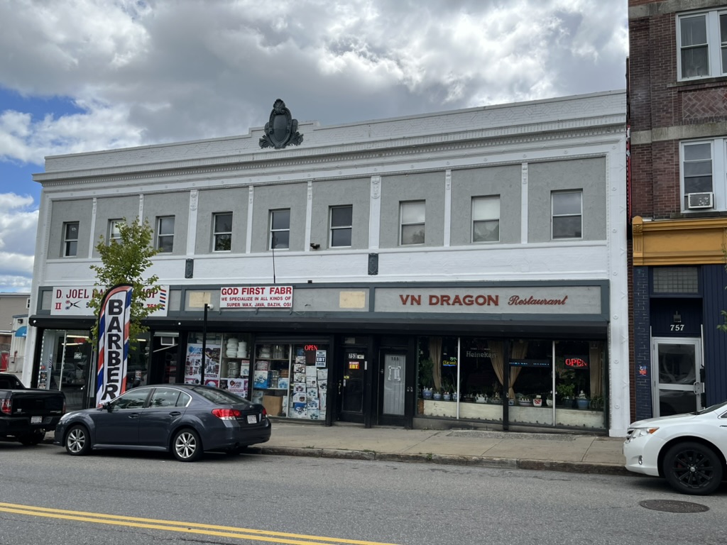


top left: The elegantly painted former automobile showroom at 783-795 Main Street, called the Anna Foley Block on the MACRIS report (1925; WOR.2108), today houses Danco African Market and a Latin-themed restaurant Sazon Bar & Grill. top right: Caribbean Vybz Restaurant, 2 Chandler Street. In the former Art Deco-style White Tower Restaurant Building (1933; WOR.2129), built on the site of the Trinity Methodist Episcopal Church seen on Triscott’s 1878 Map, corner of Chandler Street and Main Street. second row left: Ha Tien Vietnamese Market at 892 Main Street, next door to second row right: Pokuaa’s Place African Market, 892 Main Street. third row top left: The former F.S. Howard Motorcar Company showroom (1917; WOR.2102) at 751-755 Main Street today houses a barber shop, an Afro-Caribbean market, and VN Dragon Vietnamese Restaurant. third row bottom left: Encanto Latino Restaurant at 704 Main Street. third row right: Hacienda Don Juan Restaurant, 875B Main Street bottom row left: a nondescript building at 870 Main Street houses the African Community and Cultural Center. Next door is a storefront church, Iglesia Apostólica Jesús El Buen Pastor, and a Chinese restaurant at 872 Main Street. bottom row right top: Latin Food Market at 877 Main Street. bottom row right: Mekong International Foods at 747 Main Street.
*****
Chapter Eight: Freudian Slippers

The cornerstone of the Pilgrim Congregational Church (1887; WOR.1318; see photo in gallery) at 909 Main Street was “laid, October 22, 1887, on the same day as that of Clark University, and the trustees and officers of these two institutions attended both exercises in a body.”38Nutt, Vol. II, pp. 817-818. The newest “congregation” to worship at the church is that of the Grace and Mercy Holiness Church, which was founded, initially as a Bible study group, in 2022. The images on the website show a very diverse group of worshipers, another illustration of the demographic changes along the road over the past century and a half.
The establishment of Clark University in 1887 provided a focal point to the expanding neighborhood. Only these days Clark is expanding beyond its original borders as institutions inevitably have a habit of doing. Clark owns quite a few of the buildings along Main Street around the main campus, including the Queen Anne style E.C. Stockwell House (1880; WOR.2403; 921 Main Street) and the Chavoor buildings at 928-934, discussed above. It also has taken over but not preserved some older buildings in the neighborhood. The large new building at 939 Main Street, directly opposite the main campus, houses the “Student Engagement Center” with a parking lot located on the site of the South Baptist Church (1896; WOR.2449; 949 Main Street) at the intersection of Gates Street and Main Street. The building still functioned as a church for a Hispanic Pentecostal congregation as recently as 2013, as evidenced from this website. However, the incessant demands of the automobile apparently were powerful enough to defeat even the faithful.
Clark University (1887; WOR.H) was founded in 1887 by Jonas Clark, a native of nearby Hubbardston, who made a fortune selling supplies to miners during the Gold Rush in California. Clark moved to Worcester in 1881 and, according to the historic structure report, “became convinced that this country needed an institution of learning where research and investigation would be encouraged to a greater degree than was possible in other American universities, where the time of the professors was devoted largely to instruction.” Clark hired G. Stanley Hall, a professor of psychology and pedagogy at Johns Hopkins, to help create such an institution.39Nutt, Vol. II, pp. 747-752. When the campus opened in 1889, it was, after Johns Hopkins, only the second graduate school in the country, although Clark College was opened in 1902 to provide undergraduate education.
Clark has two great claims to fame: the first was the visit in September 1909 of Sigmund Freud, who gave a series of influential lectures (in German) over five days on his only American visit.40Incidentally, also in attendance at the conference, held to celebrate the twentieth anniversary of Clark University, was Carl Jung, another giant in the field of psychology, the anthropologist Franz Boas, and the political activist Emma Goldman. According to an article in the Worcester Telegram, the lectures were an enormous success: “He wrote later that when he stood up to talk before that distinguished group ‘it seemed like the realization of some incredible day dream.’ From 1909 to 1915 he was at the peak of his career, recognized in Europe and America as the pioneer creator of the new ‘talking cure.'” As I mentioned earlier, Freud stayed at the Standish Apartments during his visit, 0.8 miles from the campus along Main Street. As I walk along the same road Freud likely walked during his stay, I find myself daydreaming about following in the footsteps of Sigmund Freud walking the Upper Boston Post Road, which is probably fertile ground for a psychiatrist reading this entry and analyzing the author. The second claim to fame is that the father of modern rocket science, Robert Goddard, went to graduate school and later performed much of his early work on rocketry as a professor at Clark University. However, as a Worcester native, there is a site dedicated to him further along the road, near to where he was raised and went to high school, so I will return to his exploits in the next entry.

*****
Clark University was built upon eight acres of land purchased by Jonas Clark upon his return to Worcester in 1881. Today the main campus is almost four times as large as the original campus, not to mention the various buildings and land off the main campus also owned by the university. The house of the president was located where today Goddard library is located. This large house on a rise, visible in the photograph above, is shown on Triscott’s map as the house of “J.C. Mason” who also owned most of the land for the original campus. The house is called “Woodland Cottage” on Ball’s 1860 map of the area. It is a charming campus that directly faces Main Street for three blocks. Stephen Jenkins visited Worcester in 1913 while traveling the Upper Boston Post Road and was critical of the campus: ““As we come into the city from Leicester… we pass the unattractive buildings of Clark University.”41Stephen Jenkins, The Old Boston Post Road. (New York: G.P. Putnam & Sons, Knickerbocker Press, 1913), p. 343. I disagree.
Another house along Main Street can be seen in the bottom left corner of the photograph above. This house, the C.G. Harrington House (1870; WOR.2340; 3 Maywood Street) is also visible on Triscott’s map; it is the house on the lot between Maywood Street and Beaver Street owned by “C. Harrington.” Although the historic structure report claims the building dates to 1870, a very similarly shaped house appears on Ball’s 1860 map in the same location, which makes it likely even older than the date ascribed to it. Regardless of its date of construction, the building was picked up and moved back from the street in 1936 so that the site could be used for a gas station. Today the building faces Maywood Street and is used as offices for Clark University, while the Admissions Offices are located on the original site of the house and later gas station.
*****
Chapter Nine: Decline and Fall

The 1833 Stebbins map above marks the road in the area where the Clark campus is located today as 2 miles from the Courthouse on Lincoln Square. Just beyond the 2-mile mark is a road leading west from Main Street, which corresponds to what is now Beaver Street. On the southwest corner of Beaver Street and Main Street is a large Queen Anne four-story brick apartment building with stores at the street level. A cast stone panel with the word “BEAVER” formed in it is set between the third and fourth floor windows. The Beaver Block (WOR.2450; 1892; 974 Main Street) is an unusual apartment building in this area, according to the historic structure report: “Most of the similar buildings in the neighborhood were built thirty years later, making this building one of the earliest of its type to be built outside of downtown; and it was located quite a bit outside. Perhaps its proximity to Clark University was the reason for it being located where it was. It also is a distinctive example of elaborate masonry design with its castellated and Romanesque elements, which along with the construction methods of its side and real elevations, suggest that it was designed and built by craftsmen more familiar with the construction of industrial buildings rather than housing.”
Directly opposite Beaver Street, on the 1833 Stebbins map, is a short path leading to the house and large estate of “S.S. Gates,” the last of the four houses along the road across the plateau before the road descends into the valley where New Worcester is located. Gates Street is named after Simon Gates, whose family had earlier settled the area west along the road closer to the border with Leicester, as we shall see in the next entry. Part of the farmland today is University Park, located across Main Street opposite the Clark campus between Gates and Crystal Street, on land acquired by the city of Worcester between 1887 and 1889. The house of Simon Gates would have been on the next lot on Main Street, facing Beaver Street between Crystal and Richards Street. Richards Street is named for Deacon David Richards. According to Caleb Wall, “on the east side of Main Street, before reaching New Worcester, occupies the site of a former dwelling on this estate, owned by the Chandlers before the revolution. Simon S. Gates owned and occupied this estate after Deacon Richards (ed. note: Richards married Rebecca Gates in 1778, and she died in 1834.)”42Wall, p. 262. See also Nutt, Vol. I. p. 219. According to the MACRIS website, the house was moved just around the corner from its original location, to 5 Richards Street: “It seems most likely that the house originally stood at the north corner of Main and Richards Street until sometime between 1886 and 1896, when it was moved back to its present location to allow the construction of a Queen Anne Style home for Madilia Scofield on its original site.” James Scofield purchased the Gates/Richards house sometime around 1870, but died shortly thereafter. The house is shown on Triscott’s map of 1878 as owned by “Mrs. J.M. Scofield.” On the Sanborn map of 1910 (#269), there is a single large house on the substantial lot facing Main Street and a smaller dwelling located at #5 Richards Street, presumably the Gates house at its new location.
Charles Nutt relates an interesting anecdote about Scofield in his History of Worcester : “The late Hon. Joseph H. Walker once told the writer that, if Mr. Scofield had lived a few years longer, South Main street would probably have become one of the most beautiful residence streets in New England. The Scofield plan was to have unoccupied land from Wellington street to Webster square so restricted that the houses on both sides of the street should be set back approximately one hundred feet. At that time, about fifty years ago, when the Ethan Allen estate occupied most of the Main street frontage from Wellington to Piedmont street, when the Oread buildings were unobscured and when there were only three or four houses between the Baptist church at the corner of Hermon street and the Walker estate at Main and Ripley, the project seemed reasonable, and it should also be remembered that from Ripley street to the two handsome residences of the Coes family at Webster square the land on both sides of Main street was largely held by a few individuals. Soon after Mr. Scofield undertook this project he became ill and died at the age of forty-seven, September 26, 1871.”43Nutt, Vol. IV, p. 618.
As the reader should be painfully aware of by now, the “Scofield Plan” was not enacted. The Walker house was demolished in 1919 to be replaced by St. Peter’s School, the Ethan Allen estate was demolished around the same time and most of the land taken up by the buildings, some of them truly ugly, along Main Street from Wellington to May Street that I described in detail in earlier chapters. The Oread buildings are no longer “unobscured,” they are non-existent and, although the Main Street Baptist Church still stands, the site of the First Baptist Church is now an empty parking lot. There are now many buildings, some interesting, some uninspired, and some in terrible shape, as well as the vacant lots mentioned earlier, between Hermon Street and the “Walker Estate” (Ripley Street). Finally, although the walk past the site of the two Coes estates a little further along Main Street will be described in the next entry..spoiler alert! they no longer exist!

As a coda to the above anecdote, the lot on which the Scofield mansion once stood, at 973 Main Street, is now occupied by a 7-11 store, surrounded by a large paved parking lot. As if it couldn’t get any worse, I take a short detour to visit the old Federal house at 5 Richards Street (listed in MACRIS as dating to 1829, but very likely older as Richards died in 1829 at the age of 78; WOR.1290), the one putative building from the eighteenth century that would be the cherry on top of an entry almost totally devoid of eighteenth-century artifacts, the source of most of my interest in this project. I have prepared for my walk on this summer day by studying the Google images in advance so that I can anticipate what I will find. The historic structure report writes of the house that “the age and relatively good preservation of the Richards house mark it as one of the better examples of the few buildings that remain from its period.” When I arrive at 5 Richards Street, instead of finding the building shown on Google Maps, I find a rubble-strewn empty lot. I should have known this might happen as there was a red cross on the building shown from the 2019 image on Google. It brings to mind the building at 862-864 Main Street I discussed earlier with its similar scarlet letter, and I fear the worst for that building as well. If there was ever an “Anti-Scofield Plan” that is surely the one being implemented instead for Main Street.

It’s all downhill from here, literally and figuratively. Ball has no buildings on the 1860 map for the next quarter of a mile beyond the Gates house. Even on Triscott’s map, there was very little development for the next few blocks along Main Street. On the south side of the street there are no buildings directly on the road for three blocks at Tirrell Street, while, on the north side, the only remaining building from Triscott’s map is the much-altered Italianate building (1870; WOR.2451; 976 Main Street) with an appended commercial block, housing a Jamaican restaurant, next door to the Beaver Block. Otherwise the map shows sizable empty lots for the next three blocks along Main Street from Richards Street to Tirrell Street.
After passing Clark University the road continues today through a mixed commercial and residential area for a few blocks before heading downhill into Webster Square. With the exception of an occasional late-nineteenth century Victorian like the Edwin Hoyle House (1888; WOR.1278; 980 Main Street) or an early-twentieth century apartment block like the Longfellow Apartments (1930; WOR.2404; 1002-1008 Main Street), built at a time when “although along the outer limits of Main Street, street cars made the journey downtown an easy one,” most of the road today is lined with commercial buildings, like the McDonalds at 995 Main Street, behind which sits the lovely compact St. Mark’s Episcopal Church (1888; WOR.1385; 6 Freeland Avenue, see photo gallery), the last of the numerous lovely churches put up in the late-nineteenth century burst of development along Main Street.
Main Street, which has figuratively been going downhill for a while, literally begins to descend into a valley after Lowell Street, a topographical feature clearly visible on Stebbins’s map (see above). Stebbins also shows, after a mile of road lined with only a handful of structures, a burst of black squares representing houses, manufacturing, and even a tavern in the area where a pair of brooks merge and over which the Upper Boston Post Road crosses. Ball has a total of ten structures on his map along Main Street from Lowell Street to Cambridge Street at Webster Square, an area he labels “New Worcester” on his map. Triscott has fourteen buildings in the same area on his map, but the focal point, the junction of Main Street, Cambridge Street, and Webster Street at the bottom the hill, is referred to by its modern name of Webster Square on the 1878 map.
The technical boundary of the Main South Neighborhood is at Cambridge Street and Mill Street, a quarter of a mile down Main Street in Webster Square, but the presence of the Webster Square Package Store opposite Lowell Street tells me that this area is more oriented toward Webster Square, as does the fact that the road begins to descend into the valley around which Webster Square is centered. Also revealing is the fact that the buildings on the old maps are clearly oriented toward the valley, and the sudden increase of large commercial buildings like the McDonald’s and the neighboring Dippin Donuts, which is more in keeping with the busier Webster Square area. Morevover, as the end of “mile 49” is a short block away at Tirrell Street, this seems a good place to end my walk through the Main South neighborhood.
*****
Conclusion. End of Mile 49.
There was no Scofield plan along Main Street in the end. In 1833 there were half a dozen buildings spread out along a mile and a half of the old road out of Worcester in 1833. After the Civil War, Main Street briefly became a fashionable residential neighborhood, with the construction of a number of handsome houses along the road in the 1860s and 1870s, followed by many of the churches that had served their downtown congregations for decades. Many of the new houses were built by wealthy industrialists or bankers who profited from the rise of Worcester as a manufacturing center in the nineteenth century. In a reverse of the phrase “follow the money” the money followed them. The growth of the economy was accompanied by the growth of the population, which created demand for more housing, and the relatively open territory southwest of the city along Main Street became a natural outlet for expansion, leading to the construction of numerous apartment buildings beginning in the 1880s, catering to the rising middle class population. Downtown businesses also found themselves crowded out and began to spread southwest along Main Street. The advent of the automobile increased demand for commercial space for sales and repair of the new mode of transportation, and Main South became a center of the automobile sales and repair industry. The automobile also opened up the possibility, for those who could afford it, of living further from downtown in more tranquil neighborhoods. Thus wealthier individuals abandoned the increasingly busy and densely-populated Main South area, particularly as immigrant populations moved in next door, often converting single family homes into multi-family apartment buildings or rooming houses and adding commercial blocks to older Victorian houses that fronted the street where the front yard once existed, the opposite of Scofield’s plan to have all the houses set one hundred feet back from the street.
The Great Depression accelerated all the negative trends and within a few short years Main South became a declining neighborhood, a status officially conferred upon it by the creation of the residential security maps that delineated neighborhoods by colored lines as an indication of relative worthiness of investment. Although Main South itself avoided being specifically “red-lined,” it nevertheless was largely considered a “definitely declining neighborhood.” Coupled with the overall decline of manufacturing and the large-scale exodus of residents to newer suburban communities, Main South entered a period of nearly terminal decline, characterized by arson, crime, drug problems, and lack of investment.
In recent years, efforts have been made to rehabilitate many of the substantial buildings that had been allowed to decay over the decades, with many old apartment buildings and former factories and warehouses converted to housing. The influx of a new wave of immigrants, opening business in the old commercial spaces, taking over the old churches, often long abandoned by their original congregation, and increasing density along the street, has resulted in a profound turnaround for a blighted neighborhood. Clark University, at the western edge of the district, has slowly expanded its footprint in the neighborhood and has even acquired and adapted some of the old buildings for modern uses.
There are still many problems along Main South. The most obvious one is the ubiquity of drug use and the concomitant shabbiness that accompanies it as disheveled groups of people collect on trash-strewn sidewalks or empty lots. Despite the efforts of organizations like the Main South Neighborhood Development Corporation, more affordable housing is needed as the population continues to expand and price pressure from the Greater Boston real estate market impacts Worcester. There is too much violence and lawlessness. Clark University is not always the best steward of the local historical artifacts, as evidenced by the demolition of the South Baptist Church for a parking lot. Too many “big box” stores are creeping in to fill the landscape, sometimes taking over empty or decaying buildings, but sometimes destroying the fabric of the neighborhood to put in another parking lot. The list goes on.
So, is Worcester expanding or contracting? Is it more like a white dwarf or a red giant? Is it an unlovely, down-on-its-luck city of dead industry and collapsing buildings, or is it a city with a remarkable legacy of impressive nineteenth century architecture being thoughtfully repurposed for modern needs? Is Main South doomed because of some lines drawn on a map a century ago, or is it an incubator for a new generation of energetic immigrants who want a better life for themselves and their children? I have tried to answer that question by creating my own fabric out of the available material. Mile 48 and mile 49 are now in the rear view mirror. I now have to move on along the Upper Boston Post Road.
*****
Despite being a longtime fan of the Irish band U2, I have learned not to listen too hard to the occasionally overwrought pronouncements of the lead singer Bono. He does, however, have one idea which, although a little sentimental and simplistic, does strike me as having some merit in the context of this article about an out-of-the-way neighborhood in a down-on-its-luck city. In an essay in Time magazine from 2022, Bono writes “The American song. It might be, America might be, the greatest song the world has never heard—yet. Think about that. America might be the greatest song the world has yet to hear.” I know, I know… it is corny and trite. And yet, as I walk through this neighborhood, trash, decay, and all, I am sure I can hear the opening notes of the song playing. After all, I can dream, can’t I?
*****
Distance traveled in this entry along the route of the Upper Boston Post Road from Worcester City Hall to Chandler Street: 1.4 miles.
Total Distance traveled along the original route of the road from the Old State House in Boston for this project: 49.0 miles.
Total Distance covered for all the walks described in Boston Rambles: 110.6 miles
*****
Afterword: A commentary on redlining and data analysis.
This section was originally part of the main text, but I decided it was not specifically about walking the road. Hence I have appended it for anyone interested in a slightly more data-driven analysis of the economic evolution of Worcester and specifically of the Main South neighborhood. Feel free to skip it.
The area south of Main Street that started at Castle and Oread Street and continued to the border with Leicester was all part of area 9, the yellow-lined district on the 1936 HOLC map. Virtually the entire southern half of Worcester below Main Street was either a red-lined or a yellow-lined district (with the exception of the Vernon Hill neighborhood far to the south). The report on area 9 that accompanied the 1936 maps succinctly captured the biases of the surveyors: “there is a small concentration of negroes southeast of Beaver Brook playground although it is not spreading [my italics] to adjacent streets. The area contains many of the poorer classes. In the eastern section three-decker houses predominate, many of which are 40 years old or more, and in a poor to fair state of repair. The western and southern sections are mostly built up with one and two family houses. The area is fairly well served by street car and motor coach lines.”
The entire north side of Main Street from May Street almost to the place where Main Street and the Upper Boston Post Road diverge at Apricot Street is part of area 5 (the 5th best area of Worcester’s 15 color-coded districts), a “blue-lined” area on the 1936 map (see above) of Worcester neighborhoods color coded by levels of “residential security,” meaning that it was considered a “still desirable” area. Today, the picture is more mixed. According to the Worcester Business Journal (WBJ) article cited earlier, area 5 is now ranked 7th of 15 in “social vulnerability” but has fallen to 13th of 15 in “percent of population below the poverty level,” which contradicts to some degree the central thesis that “the way the map was drawn is largely how the city is shaped today in terms of wealth. The map not only set the standards for its day, but it locked neighborhoods into economic cycles, where those who scored worst are still at the bottom.” It also does not help the central thesis that the Main South neighborhood, as officially shown on a map (see above) provided by the Main South Community Development Corporation, does not align with area 15, the “red-lined” district on the 1936 map, except for a few blocks along the southern edge. It is therefore inaccurate to say, as the WBJ article does, that “the Main South area was the worst neighborhood in the city in 1936” as area 15 is not the same as the Main South neighborhood.
Area 15, the red-lined “hazardous” area, includes a large swath of South Worcester, located in a valley that was divided even in 1936 by gas plants and rail yards. Area 1, the only area that was “green-lined” in Worcester, indicating it was the best neighborhood, was on the hills west of Worcester Polytechnic Institute and was considered a “high class residential section. Many of the more well-to-do live in the Hancock section (M-12) in homes costing from $40,000 to $75,000,” according to the report. This remains true today and, to me, seems completely unsurprising. The factors that made area 15 undesirable have not been alleviated; one might argue that, since the area was already fragmented by transportation lines and industrial infrastructure, the addition of an interstate highway to the area was a logical choice rather than building it in areas with substantial amounts of high quality housing. The interstate unfortunately and, contrary to the argument of the article, was also pushed through some of the “better” neighborhoods, tearing apart neighborhoods in “blue-lined” sections of town as well; (see my entry Worcester, Part One for more). That said, let me be clear that I am not in favor of the construction of interstate highways at all, so I am not making that argument.
Today, despite the presence of the fantastic Miss Worcester Diner, where I had lunch one recent afternoon, area 15 remains a lousy neighborhood. Area 15 today is comprised principally of Census tracts 7325 and 7330, with only a small section overlapping with the Census tracts that comprise the official “Main South” neighborhood. The approximately 5,550 people that reside in the two Census tracts (7325 and 7330) are approximately one third White, one third Hispanic, about 15% Black, and 7% Asian, with another 5% identifying as mixed race or more than one race. Contrast this data with the two Census tracts that comprise the “yellow-lined” area of the Main South area, tract 7314, which takes in most of the former Allen/Chandler/Ward Estate north of Main Street, and 7313, which includes the area south of Main Street from Wellington Street all the way to University Park opposite Clark University, including a small swathe of red-lined area 15. The 9,800 residents of these two census tracts are only about 18% White, 15% Black, 55% Hispanic, and 8% Asian, with about 4% identifying as mixed race or of multiple races.
Not only is the “yellow-lined” district less white than the “red-lined” district, the Household Median Income (HHMI) is also lower in the yellow-lined district, about $32,000 compared to over $40,000 in the census tracts comprising the red-lined area 15. This data does not include the Census tracts that comprise the “blue” area 5 that makes up a large part of the Main South neighborhood around Clark (Census tracts 7312.02 and 7313.03), which is substantially whiter but has about the same HHMI ($32,000) as the “yellow” area. My point in displaying all this data is to show that the claims in the article do not match the data and that the “red-lined” area in 1936 is not the poorest area today. The poorest area in Worcester is not even Main South; it is the Great Brook Valley area in the north of the city, which I discussed in my first entry about Worcester. Redlining had a deleterious impact on Worcester and other cities in America and the programmatic approach had racist overtones, but the problems in Main South cannot all be laid at the feet of the HOLC mapping program of the 1930s.
The article also strongly implies that race was the principal factor in the decision to “color” certain areas; As the Non-White population of Worcester was quite small in the 1930s, less than 1% of the total population in 1940, according to the Mapping Inequality website, I would argue that it was more about poverty and infrastructure, but this is a complicated debate I cannot afford to spend the time on in this already long article. I would also argue that “race” and “racism” are very slippery terms that can change over time: some groups, like Irish and Italian immigrants, “became white” but were often considered differently in earlier eras. 44Once again, for a more nuanced and substantive look at this topic, I suggest Richard Rothstein, The Color of Law: A Forgotten History of How Our Government Segregated America. New York: Liverwright, 2017.

Conversely, although “nice” neighborhoods do sometimes decline, as I have tried to show happened along South Main Street over the course of six or seven decades after the Civil War, the very nicest seldom completely collapse. Thus the argument in the article would have been stronger in my opinion if the authors had spent more time analyzing the neighborhoods that were not the “best” or the most “hazardous” and instead examined the ones in the next tiers to see what happened in general to these areas. For example, the accompanying chart showing the 15 areas from the 1936 map ranked by the Social Vulnerability Index in 2020, taken from the WRRB report, clearly shows volatility in the areas not ranked at the very top or the very bottom. What circumstances have caused these changes? That the lovely massive mansion on Massachusetts Avenue near the American Antiquarian Society (green area 1) is still lovely and expensive, and the dilapidated three-decker on Grand Street next to the rail yards is still dilapidated (red area 15) is not unexpected. Why, on the other hand, is Main South in an unstable situation, if most of it was not red-lined and, indeed, a substantial portion was considered “still desirable” in 1936? Area 5 and area 9, the areas comprising the overwhelming majority of Main South, were middling areas in 1936, as evidenced by their assigned ranks out of 15 areas in Worcester. The evidence provided by the report and the conclusions drawn in the article about the report are not supported by the data.
There is one more complication to the somewhat simplistic arguments made in the WBJ article. Against the backdrop of what may or may not have been a policy that locked neighborhoods into economic cycles from which they cannot escape, one must also deal with the general decline of Worcester’s economic clout over the course of the past few decades. Just as a rising tide lifts all ships, when the tide is exceptionally low ships that were afloat often end up lying on their sides in the mudflats. Many of the neighborhoods discussed in this entry have been affected at least as much by the general economic decline of Worcester as by redlining, especially the “blue” area around Clark and the “yellow” areas that make up most of this walk through Worcester. Adam Davidson, founder of NPR’s Planet Money, wrote an article for the New York Times in 2016 entitled “What Happened to Worcester? ” which discusses the changes in the city since the time his great-grandparents settled there around 1917. Davidson argues that his ancestors, who were united mainly by their poverty when they settled in Worcester, were able to make a success of their lives because of “middle” cities like Worcester, with their mix of manufacturing jobs which, in turn, attracted immigrants to work and to produce and sell goods to the burgeoning population in a “virtuous circle,” a circle which collapsed by the 1980s.
Fortunately Davidson sees the rise of a new virtuous circle but that the story is more complicated today and the picture is not as clear: “Worcester is filled with contradictory sights: crumbling infrastructure, decaying homes, yet fresh paint and siding and other signs that someone is making some money, trying to create a good home. This is the tension in much of the city — collapse of an old way of working combined with a new, hard-to-discern promise — that makes Worcester so representative of the overall U.S. economy.” The WBJ article, on the other hand, uses the Davidson article in the New York Times as a foil against which to argue that stasis rather than “figuratively climb(ing) the social ladder” has been the norm for people locked into “red-lined” neighborhoods.
I have spent more than six months walking the route of the Upper Boston Post Road through Worcester, passing back and forth multiple times across the city through every neighborhood (including green, blue, yellow, and red-lined areas) along an eight-mile stretch of the old road. Along the way I have spent many hours wandering through other areas of the city, exploring the neighborhoods where I spent my college days and neighborhoods I had never previously visited, like the so-called area 15 of South Main and South Worcester. I agree that the areas through which the road passes that have been historically demarcated as “less desirable” are, for the most part, still less desirable. I also think that, as a result of this lack of desirability, they are one of the few places newly arrived immigrants with little or no money can find opportunities to succeed.
The Census tracts (7314 and 7313) in the “yellow-lined” areas of Main South both have much higher rates of foreign-born residents (35%, and 39% respectively) than the 23% figure for the City of Worcester. The tracts also have some of the highest rates of renter-occupation (90% and 93%) in the city, which does indeed bring extra price pressure when demand for real estate is high. The problems described in the WBJ article and in the WRRB report are real and need to be addressed. However, the emphasis on a government program from nearly a century ago is misguided at best and lazy at worst: not only does the data not support the statements made in the article, the demographic makeup of the city and, more specifically, of the areas under discussion, have changed almost completely during the last few decades. It is an apples to oranges comparison that does not suit the problems that exist now. I would argue that, much like the Albion apartments discussed above, things are actually much better than they have been in quite a while in Main South. Some credit must go to neighborhood organizations and government programs aimed at revitalizing the area, but I offer an even simpler argument: the same economic forces that caused the decline of the neighborhood in the first place are now working in reverse to improve the neighborhood. Namely, the new economic dynamic along Main Street brought about by the dramatic increase in the number of newly arrived immigrants who want a better life, a group that by their sheer number create an economic virtual circle by taking jobs others do not want, by opening their own businesses, by investing money in the neighborhood, by keeping the schools and churches and community organizations vibrant.
Many of the people who have made the difficult decision to uproot themselves from their homeland and settle in a new country will likely have a much better life than they might otherwise have had, while many of their children will go on to be successful participants in the American success story. Some will not, and that is where the efforts to help those who have fallen through the cracks need to be directed. On the whole, however, my guess is that the vast majority of immigrants to these “red-lined” neighborhoods see the place very differently than we who live in “nicer” neighborhoods see these places. Anecdotally, I know this to be true: I spoke with the proprietors of one of the stores along Main Street, a couple who arrived in 1999 from Ghana, and they expressly stated that there were many more opportunities to succeed here than in their homeland and that they liked the neighborhood in which their store was located, despite also telling me they frequently have to ask people not to lay on the sidewalk in front of the door of their store, that the owner was shot by a BB-gun from a passing car recently as he was closing the shop, and that, while I was standing there talking to the owners in the middle of the day, one of the people I had seen on the sidewalk a block or two away only minutes earlier had come into the store and was attempting blatantly to shoplift as we watched, apparently oblivious to our presence.
Incidentally, the Gross Domestic Product per Capita (an imperfect but still useful tool for assessing per capita income) in Ghana is a little over $2,000 per year, and reaches only around $7,000 per person if adjusted for prices in Ghana (GDP-PPP). I remind the reader that the Household Median Income for the area is $32,000, with an average of 2.5 people per “household” in the district, comes out to about $13,000 per person. That number does not include various government programs aimed at helping low income families, such as WIC and SNAP, which many countries in the developing world are unable or, in some cases, unwilling to support.
I am not saying things are great, all I am saying is that they are better than in some other places in the world. I suspect it is much nicer to live in “hazardous” area 15, and certainly in “still desirable” area 5 and “declining” area 9, which are bisected by Main Street, warts and all, than to live in a hut with no running water in Honduras or in Haiti, or in a refugee camp in Darfur, or Syria, or Myanmar, or any number of the too many countries suffering from civil wars, or in an overcrowded village on the coast of Liberia or Vietnam or Bangladesh slowly disappearing under a rising tide. It is illogical to expect that people who arrive in the United States from the 90% of the world where the average person has less than 10% of the wealth the typical American possesses will settle anywhere but the “worst” neighborhoods, unless they are extraordinarily lucky, while they start climbing the ladder from the bottom rung. At least there is a ladder.